

Severe Thunderstorm Warning for Marengo/Hale

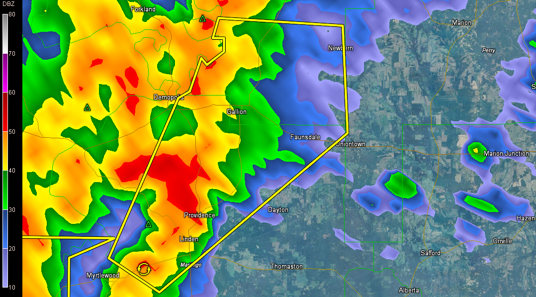
A severe thunderstorm warning has been issued for parts of Hale, Marengo [AL] till 8:45 AM CST.
It will pass near or between Faunsdale and Gallion.
Dangerous storm near Linden will cross US-80 between Demopolis and Uniontown, eventually heading toward Newbern.
THE NATIONAL WEATHER SERVICE IN BIRMINGHAM HAS ISSUED A
* SEVERE THUNDERSTORM WARNING FOR…
SOUTHERN HALE COUNTY IN WEST CENTRAL ALABAMA…
NORTHERN MARENGO COUNTY IN SOUTHWEST ALABAMA…
* UNTIL 845 AM CST
* AT 757 AM CST…THE NATIONAL WEATHER SERVICE INDICATED A SEVERE
THUNDERSTORM CAPABLE OF PRODUCING DAMAGING WINDS IN EXCESS OF 60
MPH. THIS STORM WAS LOCATED NEAR MYRTLEWOOD…OR NEAR LINDEN…AND
MOVING NORTHEAST AT 60 MPH.
* LOCATIONS IMPACTED INCLUDE…
LINDEN…PIN HOOK…CHICKASAW STATE PARK…ARCOLA…FAUNSDALE…
NEWBERN…PROVIDENCE AND OLD SPRING HILL.
WINDS OF 60 TO 70 MPH WILL BREAK LARGE TREE LIMBS AND CAUSE SOME
DAMAGE…ESPECIALLY TO SMALLER STRUCTURES.
Category: Alabama's Weather, Severe Weather
About the Author (Author Profile)
Bill Murray is the President of The Weather Factory. He is the site's official weather historian and a weekend forecaster. He also anchors the site's severe weather coverage. Bill Murray is the proud holder of National Weather Association Digital Seal #0001 @wxhistorianSubscribe
If you enjoyed this article, subscribe to receive more just like it.


