

Severe Thunderstorm Warning : East Central Talladega County 9:15

The most intense part of the storm is near Curry at 8:48. It will travel up AL-31 toward Munford and Cross I-20 near the Anniston Airport. Eventually it will reach Oxford.
Be prepared for 60-70 mph winds as this dangerous storm approaches.
Skywatcher Jeff White was on this storm earlier as it passed near Sylacauga. He reports:
James – I unfortunately was on the bad side of this storm approaching me head on and had a hill between me and Sylacauga and until the rotation topped the hill I could not identify and by time I could it was over me and gone – moving so fast and was about 500 feet aloft where I could see the rotation in the lowered cloud base and then could see the inflow when the rotation was to my east and I was looking at the direct east side of the rotation.
He says it is he first time he had ever heard the low rumble like a sub woofer far off as it came over the hill and over them.
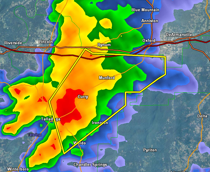
THE NATIONAL WEATHER SERVICE IN BIRMINGHAM HAS ISSUED A
* SEVERE THUNDERSTORM WARNING FOR…
EAST CENTRAL TALLADEGA COUNTY IN EAST CENTRAL ALABAMA…
* UNTIL 915 AM CST
* AT 847 AM CST…THE NATIONAL WEATHER SERVICE INDICATED A SEVERE
THUNDERSTORM CAPABLE OF PRODUCING DAMAGING WINDS IN EXCESS OF 60
MPH. THIS STORM WAS LOCATED NEAR WALDO…OR NEAR TALLADEGA…AND
MOVING NORTHEAST AT 60 MPH.
* LOCATIONS IMPACTED INCLUDE…
GRANT TOWN…ANNISTON REGIONAL AIRPORT…CAMP MAC…JENIFER AND OAK
HILL.
THIS INCLUDES…
INTERSTATE 20 EXIT NUMBERS 173 THROUGH 179…
WINDS OF 60 TO 70 MPH WILL BREAK LARGE TREE LIMBS AND CAUSE SOME
DAMAGE…ESPECIALLY TO SMALLER STRUCTURES.
PRECAUTIONARY/PREPAREDNESS ACTIONS…
FOR YOUR PROTECTION…MOVE TO AN INTERIOR ROOM ON THE LOWEST FLOOR OF
YOUR HOME OR BUSINESS.
Category: Alabama's Weather
About the Author (Author Profile)
Subscribe
If you enjoyed this article, subscribe to receive more just like it.


