Boston Snowfall Makes Their Top Ten List
The 21.8 inches of snow through 7 a.m. at Boston’s Logan Airport is not an all time record there, but it did make the top ten. Some additional snow fell after 7 a.m., which could have been enough to push the storm total into the top five.
Here is the current list through 7 a.m.
1. 27.5″ 2003 February 17-18
2. 27.1″ 1978 February 6-7
3. 26.3″ 1969 February 24-25
4. 25.4″ 1997 March 31 – April 1
5. 22.5″ 2005 January 22-23
=====================================
6. 21.8″ 2013 February 8-9
=====================================
7. 21.4″ 1978 January 20-21
8. 19.8″ 1960 March 3-5
9. 19.4″ 1958 February 16-17
10. 18.7″ 1994 February 8-10
We will update the ranking later.
It looks like blizzard conditions were confirmed at Falmouth AFB in Massachusetts. Here are the obs during the early morning, focusing on the ones between 2:15 and 5:35.
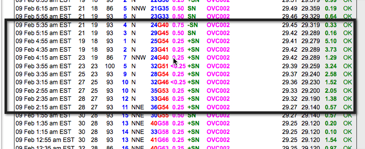
The NWS defines a blizzard as:
…the following conditions are expected to prevail for a period of 3 hours or longer:
Sustained wind or frequent gusts to 35 miles an hour or greater; and
Considerable falling and/or blowing snow (i.e., reducing visibility frequently to less than 1/4 mile)
It could be argued that the blizzard conditions started as early as 12:35 a.m.
It looks to me like the readings at Boston’s Logan fell just short of the definition, although they were close.
So far, the highest snow total I have seen out of the NWS Boston is 32.0 inches at Manchester CT.
The snow is definitely tapering off now as the low departs to the northeast. Here is a picture of the low with satellite and radar, as well as the isobars.
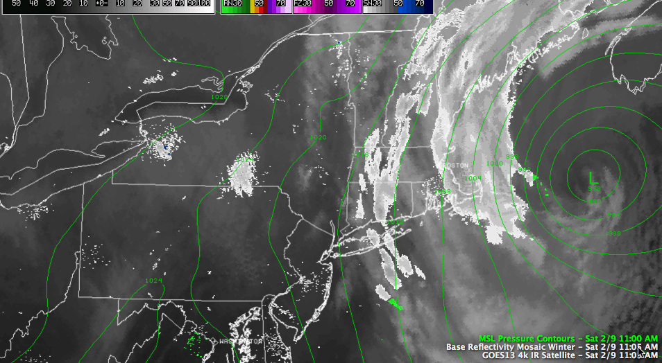
The pressure now is 978 mb. I have seen an estimate as low at 974 mb.
Category: Headlines, Winter Weather
About the Author (Author Profile)
Bill Murray is the President of The Weather Factory. He is the site's official weather historian and a weekend forecaster. He also anchors the site's severe weather coverage. Bill Murray is the proud holder of National Weather Association Digital Seal #0001 @wxhistorianSubscribe
If you enjoyed this article, subscribe to receive more just like it.


