

Severe Update: Threat Shifts More to the South
Resetting the severe weather situation across Alabama just after mid-afternoon.
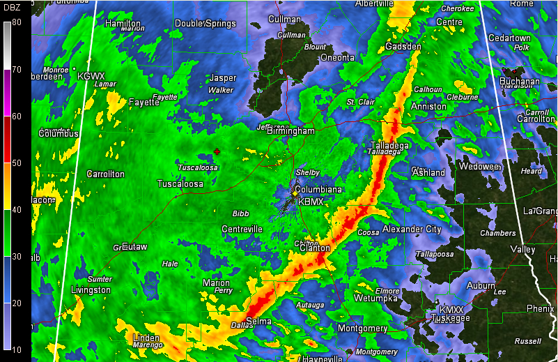
A narrow line of strong storms is pushing across Central Alabama at this hour.
It extends from Ohatchee to Talladega to Sylacauga to Billingsley to Selma at this hour. It is pushing east at nearly 50 mph, but the southern end of the line is slowing a bit, like it did in Mississippi.
The line is accompanied by brief torrential rains, strong gusty winds and lightning.
The slowing line of storms has laid down a boundary across South Central Mississippi with fairly unstable air producing supercell thunderstorms to the south of it and just rain and elevated thunder to the north.
The large mass of rain and thunder over northern Mississippi will continue to push eastward across North Central Alabama through the afternoon and evening with the back end gradually pushing southeastward. The back edge of the rain should reach I-59 by 10 p.m. – midnight, with gradually diminishing rainfall after 7 p.m.
The highest chance of severe weather will be south of a line from Butler to Linden to Selma to Montgomery to Aelxander City, south of where the line of storms ends up.
A tornado watch remains in effect until 11 p.m. for Southwest Alabama, including Marengo and Dallas Counties in our area.
The flash flood watch has been extended in time and area to include all of Central Alabama. It goes til midnight over western sections and until 6 a.m. over the rest of the area.
Category: Alabama's Weather, Severe Weather
About the Author (Author Profile)
Bill Murray is the President of The Weather Factory. He is the site's official weather historian and a weekend forecaster. He also anchors the site's severe weather coverage. Bill Murray is the proud holder of National Weather Association Digital Seal #0001 @wxhistorianSubscribe
If you enjoyed this article, subscribe to receive more just like it.


