Operation Snow Watch
I say that tongue in cheek, since this will not be a significant snow event in any way for North or Central Alabama.
But snowflakes are flying across parts of northern Alabama and northern Georgia, so I will declare Operation Snow Watch officially in effect.
A few snow flurries have been reported near Mentone and over in Rome GA with a mix near Fort Payne earlier. Snowflakes were flying in Hackleburg and Pride AL according to reports. It was spitting snow in Oneonta according to a report on Twitter.
Within the past hour, the PING project has picked up two reports of snow from Kimestone and Madison Counties, with an ice pellets/snowflake mix out of Cullman county.
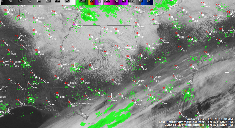
Radar is showing a few spits and sputters of snowflakes over Northwest Alabama, mainly over Franklin, Marion and Winston Counties, with more back toward Corinth MS that will be pushing into Alabama later. But these won’t cause any accumulations.
Clouds are thick across the northern half of Alabama, extending down into South Central Alabama. They will continue to thicken through the afternoon as some mid level moisture slides into the area in association with the big upper trough that is moving our way.
There is still a little bit of sun down around Auburn and over in LaGrange GA. Temperatures are in the lower 40s in the I-20 corridor at this hour, with upper 30s over the Tennessee Valley.
Any accumulations will come tonight and Saturday morning as snow showers develop in the slight instability caused by the cold temperatures with the trough moving across.
Accumulations will be small, from nothing at any to spotty dusting to 1/2 inch amounts, mainly for areas north of a line from Reform to Hoover to Wedowee. The best chance will be in the higher elevations north and east of Birmingham. Any accumulations will be on grassy areas and roads should not be a problem.
The best chance for snow in the Birmingham area should be Saturday morning between 6 and noon, mainly between 6 and 9, when the better moisture will be in the snow growth regions aloft.
As always with these kinds of events, there will be surprises. Areas that see a heavier snow shower could see a quick coating on grassy areas.
Central Alabama could see snow flurries Saturday morning as far south as the US-80 corridor.
The best chances for an inch of snow will be across southern Kentucky, extending down into Middle Tenenssee. It is snowing at Paducah and Hopkinsville KY at this hour.
Add your precipitation reports below.
Category: Alabama's Weather
About the Author (Author Profile)
Bill Murray is the President of The Weather Factory. He is the site's official weather historian and a weekend forecaster. He also anchors the site's severe weather coverage. Bill Murray is the proud holder of National Weather Association Digital Seal #0001 @wxhistorianSubscribe
If you enjoyed this article, subscribe to receive more just like it.


