Talking Disturbances, Troughs, Vort Maxes
Click image to enlarge.
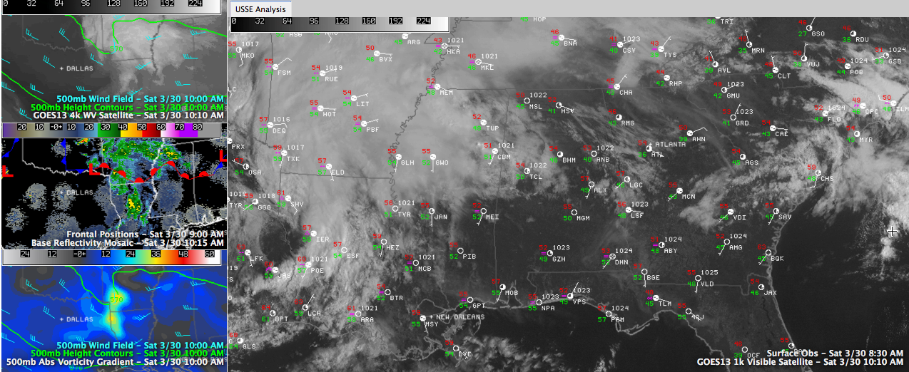
You hear us talk about upper disturbances all the time, and here is an example of a very visual one.
Look at the top left panel of the image to see the water vapor satellite image overlaid with the pattern at 18,000 feet. See the distinct kink in the wind bars, and the trough over the western Arkansas/eastern Oklahoma border? That’s your upper level trough, or upper level disturbance.
The middle left panel shows the radar with the surface features also displayed. You can see a warm front lying generally along I-20. There is a weak surface low associated with the upper level disturbance near Texarkana, AR/TX.
We also sometimes refer to these upper level disturbances as vort maxes, or vorticity maximums. These are areas where vorticity, or spin in the atmosphere, is maximized. You can see that in the yellow colors on the lower right hand panel of the graphic. Vort maxes are associated with rising air, and accordingly rain and storms.
Earlier there were a couple of severe thunderstorm warnings in Oklahoma, but the storm have weakened.
The large panel shows the visible satellite, with a good bit of sunshine in place across all but western Alabama. Temperatures are in the 50s now, heading for a rendezvous with 70F later today. Cloudier spots may remain in the upper 60s. Sunnier spots could reach the lower 70s.
That warm front will lift northeast through the afternoon, spurred by the surface low. The front will be accompanied by a round of showers with the chance of a little thunder. Then as the disturbance slides across the central part of the state late this afternoon and this evening, you will see another round of showers. You might hear a clap or two of thunder, but the storms won’t be strong or severe.
Expect more showers and more storms Sunday. Hopefully, morning events will be dry.
Category: Alabama's Weather
About the Author (Author Profile)
Bill Murray is the President of The Weather Factory. He is the site's official weather historian and a weekend forecaster. He also anchors the site's severe weather coverage. Bill Murray is the proud holder of National Weather Association Digital Seal #0001 @wxhistorianSubscribe
If you enjoyed this article, subscribe to receive more just like it.


