

Severe Thunderstorm Warning Cherokee County until 4:15PM

Thunderstorm over Cherokee County has continued to intensified this afternoon and has reached severe limits. Severe hail and damaging winds could be occurring with this storm over the southern part of the county. U.S. 278 and 411 are being impacted by this storm as well as the communities of Rock Run, Pine Grove and Spring Garden.
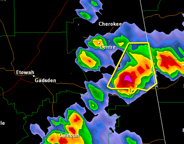
THE NATIONAL WEATHER SERVICE IN BIRMINGHAM HAS ISSUED A
* SEVERE THUNDERSTORM WARNING FOR…
SOUTHEASTERN CHEROKEE COUNTY IN NORTHEAST ALABAMA…
* UNTIL 415 PM CDT
* AT 324 PM CDT…THE NATIONAL WEATHER SERVICE INDICATED A SEVERE
THUNDERSTORM CAPABLE OF PRODUCING QUARTER SIZE HAIL…AND DAMAGING
WINDS IN EXCESS OF 60 MPH. THIS STORM WAS LOCATED NEAR PLEASANT
GAP…OR 6 MILES NORTHEAST OF PIEDMONT…AND MOVING NORTHEAST AT 5
MPH.
* LOCATIONS IMPACTED INCLUDE…
FORNEY AND PLEASANT GAP.
PRECAUTIONARY/PREPAREDNESS ACTIONS…
FOR YOUR PROTECTION…MOVE TO AN INTERIOR ROOM ON THE LOWEST FLOOR OF
YOUR HOME OR BUSINESS.
Category: Alabama's Weather, Severe Weather
About the Author (Author Profile)
Subscribe
If you enjoyed this article, subscribe to receive more just like it.


