8:30 PM Update
SEVERE WEATHER RISK: Severe thunderstorm watch remains valid until midnight tonight for portions of north central Alabama. Within the last hour, some counties in West Alabama have been trimmed out of the watch as the atmosphere has started to stabilize with the loss of daytime heating. The SPC maintains a slight risk for severe weather over portions of northwest Alabama until 7 AM tomorrow morning.
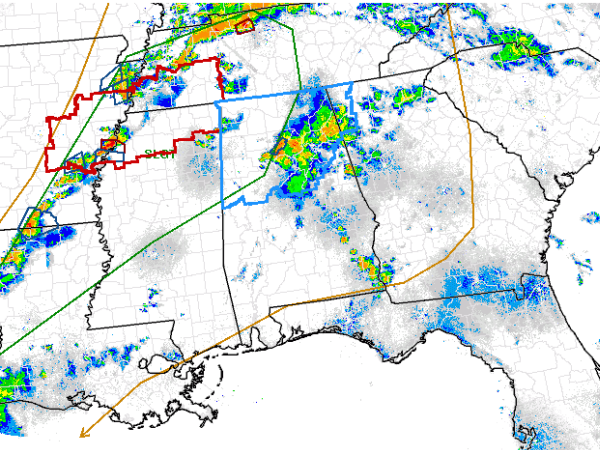
RADAR CHECK: Most areas across Alabama remain fairly calm. A cluster of strong, and isolated severe storms continues to move east across the northern sections of the Birmingham metro. Earlier these storms were producing very large hail and damaging winds. The have weakened some, but still could be producing some pea and marble size hail. Frequent lightning would appear to be the greatest threat from these storms currently.
WHAT TO EXPECT OVERNIGHT: Most areas over West Alabama have cleared out and will see little activity for the next few hours. As the ongoing storms continue to move east, this clearing will continue to move east as well. We will have to monitor the activity off to our northwest as it drops south overnight, but hopefully, it will weaken and fall apart before making it to Alabama. It looks as though scattered showers and thunderstorms will be possible through out the night and wet conditions look likely to greet you in the morning. The severe weather parameters have come down the last few hours, and it looks as though we could make it through the night with little to no other severe weather.
Category: Alabama's Weather, Severe Weather
About the Author (Author Profile)
Macon, Georgia Television Chief Meteorologist, Birmingham native, and long time Contributor on AlabamaWX. Stormchaser. I did not choose Weather, it chose Me. College Football Fanatic. @Ryan_StinnetSubscribe
If you enjoyed this article, subscribe to receive more just like it.


