Very Cool, Showery Weather Continues
An all new edition of the ABC 33/40 Weather Xtreme video is available in the player on the right sidebar of the blog. You can subscribe to the Weather Xtreme video on iTunes by clicking here.
UPPER LOW CREEPING ALONG: The deep, cold core upper low that brought showers, hail, cold air funnels, and a few bright rainbows to Alabama yesterday is near Rome, Georgia this morning. On the west wide of the low, a band of moderate to heavy rain continues over Northeast Alabama at daybreak… places like Centre, Cedar Bluff, Gaylesville, Crossville, Geraldine, and Lake Guntersville are soaked, and some minor flooding is very possible.
Elsewhere, the day begins dry and cold with most places in the 40s. Montgomery reports 46 degrees… very close to their record low of 44 set in 1954.
THE DAY AHEAD: Due to the upper low, again we will dodge occasional showers today over the northern half of Alabama; the most numerous ones should be from Birmingham north and east. I don’t expect as much hail as yesterday, but there is still the chance of hail in the heavier showers, especially over Northeast Alabama.
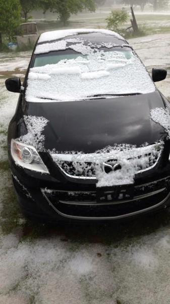
Below is a shot of hail at Locust Fork yesterday (photo by Heather Bowens)…
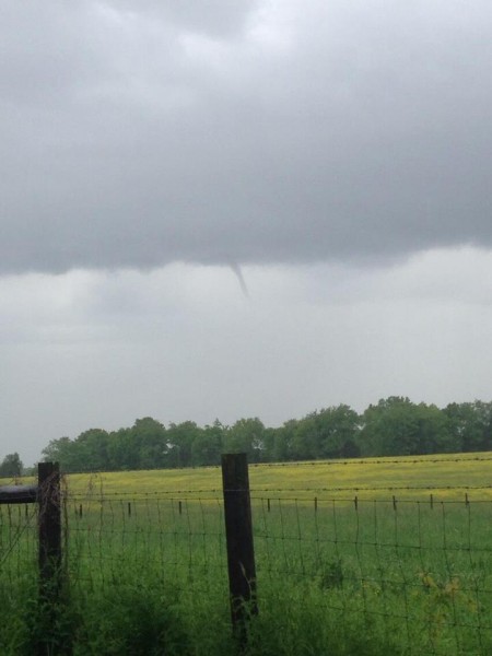
We also had a few cold air funnels yesterday… don’t expect them today since the upper low is now east of the state and moving away. The photo below is from @thechrisolson over the Tennessee Valley
Temperatures will remain very cool; the GFS is printing a high of only 61 degrees for Birmingham today; the record low maximum temperature for May 6 is 61 set in 1992… so it could be another record “cool” day for May. We note Tuscaloosa set a new all-time record minimum high temp for the month of May with yesterday’s reading of 58 degrees.
MID-WEEK: A warming trend finally begins tomorrow; we reach the low 70s with a partly to mostly sunny sky. I guess we might consider a slight risk of a shower for Northeast Alabama, but most places there will be dry as well.
Temperatures should reach the upper 70s Wednesday, and low 80s Thursday as the warm-up continues and we finally feel like May in Alabama. The sky should be generally sunny on these two days.
FRIDAY AND THE WEEKEND: Moisture begins to return Friday, and we will mention the chance of a shower Friday afternoon and Friday night. But, the most widespread rain will hold off until Saturday as an upper low moves out of the Southwest U.S. Periods of rain are likely Saturday and Saturday night; it won’t rain all day, but it could rain at any time. Rain amounts of 1/2 to 1 inch are likely… and while some thunder is possible we don’t expect any severe weather issues for now.
Then, on Sunday, a cold front will pass through the state. The rain will end from northwest to southeast during the day, and we will turn sharply cooler Sunday night as the sky clears.
NEXT WEEK: We project a low down in the 40s early Monday… not far from record values once again. But, we rise into the low 70s Monday afternoon. The sky should be sunny Monday and Tuesday as dry, continental air covers the state.
See the Weather Xtreme video for the maps, graphics, and more details.
WEATHER BRAINS: Don’t forget you can listen to our weekly 90 minute netcast anytime on the web, or on iTunes. This is the show all about weather featuring many familiar voices, including our meteorologists here at ABC 33/40. We will produce this week’s episode tonight at 8:30 p.m. CT… you can watch live right here, or on our digital weather channel called “James Spann 24/7”.
CONNECT: You can find me on all of the major social networks…
Facebook
Twitter
Google Plus
Instagram
I have a weather program today at Helena Elementary School…. look for the next Weather Xtreme video here by 4:00 this afternoon. Enjoy the day!
Category: Alabama's Weather


