A Couple of Showers/Storms over East Alabama
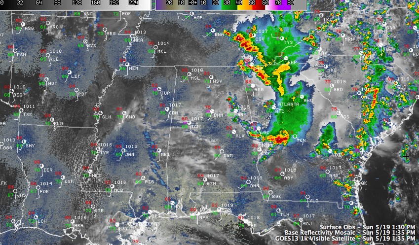
Showers and thunderstorms have been widespread across eastern Tennessee and northern Georgia today. The storm complex over west central Georgia has prompted a severe thunderstorm watch and several warnings.
At one point, flash flood warnings blanketed counties three deep into western Georgia.
Outflow from the storms pushed west into eastern Alabama triggering a few showers and storms as well. One storm is between Rainbow City and Southside in Etowah County.
Showers and storms should be limited to our easternmost counties, from Jackson and DeKalb, through Etowah and Cherokee into Calhoun and Cleburne Counties, and into Clay, Randolph, Tallapoosa and Coosa Counties.
Storms may expand in coverage and intensity across South Central Alabama from the Auburn area back to Montgomery and Selma.
West of that, skies are trying to slowly clear. The most sunshine has been over the northwestern part of the state. It was 85F last hour at Muscle Shoals and 80F in Haleyville. It was 80F at Tuscaloosa, 77F at Birmingham and 71F at Anniston.
Over the Plains, convective initiation has started over Central Kansas. A tornado watch is in effect now for southern Nebraska, much of Kansas and northwestern Missouri, including Kansas City. Another watch will be coming up soon for much of Central Oklahoma. To the north, anotehr tornado watch is in effect for parts of Iowa and Minnesota.
Category: Alabama's Weather, Severe Weather
About the Author (Author Profile)
Bill Murray is the President of The Weather Factory. He is the site's official weather historian and a weekend forecaster. He also anchors the site's severe weather coverage. Bill Murray is the proud holder of National Weather Association Digital Seal #0001 @wxhistorianSubscribe
If you enjoyed this article, subscribe to receive more just like it.


