Watching The Gulf
An all new edition of the ABC 33/40 Weather Xtreme video is available in the player on the right sidebar of the blog. You can subscribe to the Weather Xtreme video on iTunes by clicking here.
THIS AFTERNOON: A quiet weather day for the northern half of Alabama… the only issue is the “mystery echo” on the Hytop radar over Huntsville near Redstone Arsenal…
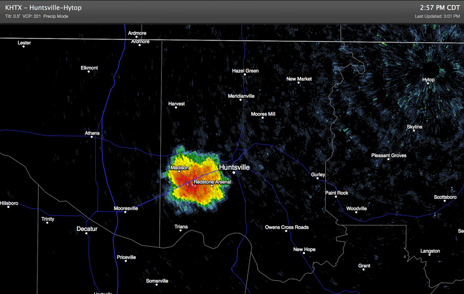
The sky over Huntsville is mostly clear, and there are no controlled burns, and the radar echo doesn’t look like chaff deployed from military aircraft. We will keep working it, but for now it remains a mystery.
Down south, we have seen a few scattered storms over the southern half of the state, but they are widely spaced.
IN THE GULF: A surface low is over the southern Gulf, drifting north. Most of the convection is well to the east of the low, and the hurricane hunter flight into the system for this afternoon was cancelled. Still, this has the potential to become a tropical depression over the next 36 hours. Depression or open wave, the impact will be the same… heavy rain over parts of Florida, and then up through Georgia and the Carolinas later in the week.
Most models want to bring the surface low up toward Panama City or Apalachicola Thursday night; the heaviest rain will come from about Panama City east… to include much of the Florida Peninsula (Orlando, Tampa, Daytona, Fort Myers, Miami, etc).
GULF COAST FORECAST: So… if you are beach bound…. look for rain at Panama City, and possibly Destin and Fort Walton Beach Thursday. And, rough surf is likely all along the Gulf Coast through Thursday night. Otherwise, about 5 to 7 hours of sunshine for Pensacola and Gulf Shores tomorrow and Thursday with scattered showers and storms. Storms will be fewer in number Friday and over the weekend with 7 to 9 hours of sun each day. Highs will be in the 80s, water temperatures are near 80.
UP THIS WAY: We are still forecasting scattered to numerous showers and storms Thursday and Friday… we still believe the heaviest rain with the tropical low will pass east of the state, but we note the 18Z NAM just in shows some heavy rain over the eastern third of Alabama Friday.
One way or another the weekend should feature drier air with only a slight risk of a shower Saturday. Then, mostly rain-free Sunday and Monday. The GFS is now advertising an upper high that might bring the hottest weather so far this year to the state early next week with low to mid 90s. Welcome to summer.
See the Weather Xtreme video for the maps, graphics, and details.
WEATHER BRAINS: Don’t forget you can listen to our weekly 90 minute netcast anytime on the web, or on iTunes. This is the show all about weather featuring many familiar voices, including our meteorologists here at ABC 33/40.
CONNECT: You can find me on all of the major social networks…
Facebook
Twitter
Google Plus
Instagram
Look for the next Weather Xtreme video here by 7:00 a.m. tomorrow….
Category: Alabama's Weather
About the Author (Author Profile)
James Spann is one of the most recognized and trusted television meteorologists in the industry. He holds the AMS CCM designation and television seals from the AMS and NWA. He is a past winner of the Broadcast Meteorologist of the Year from both professional organizations.Subscribe
If you enjoyed this article, subscribe to receive more just like it.


