

Storms Dropping South, An Active Friday
Some showers and thunderstorms developed over East Alabama this evening. A few of them even reached severe limits and did produce tree and power line damage in several counties southeast of Birmingham. These storms have since pushed out of our CWA. Over the last few hours some additional strong storms developed along a boundary in Central Alabama. These storms are pushing south and should continue to dissipate over the next few hours. The most intense activity is currently along the Interstate 65 around Jemison and farther south and along Interstate 85 as well. Frequent lightning, torrential rain, and small hail are occurring with these storms.
There is quite a bit if severe weather across the Plains this evening. These storms have clustered together into a MCS. Northwest flow aloft will drive these complexes Southeast through the overnight hours. If these storms were to hold together they could be impacting Alabama tomorrow morning. Just something to keep in mind as most areas should remain calm the rest of tonight.

Heading into Friday, the SPC has much of Alabama included in their standard slight risk for severe weather. A frontal boundary will be diving into Alabama tomorrow and will provide uplift for a very warm air mass in place across the state. More widespread and organized severe weather is expected across Alabama. Storms this time of year rarely have tornadoes with them, but hail and damaging winds are of greatest concern. This will holds true for Friday as well. We will have to watch for isolated flash flooding and all storms will have very dangerous and frequent lightning.
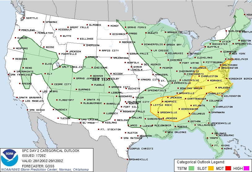
The MCS discussed earlier, even if it does not impact Alabama, it will certainly be sending out outflow boundaries. These boundaries along with the front will be what enhances our chance for showers and thunderstorms tomorrow. Once again, storms will be strong and several are likely to become severe over the course of the afternoon and evening as a very unstable air mass will provide ample fuel for this convective activity. Here is the overall picture of what is expected tomorrow.

Category: Alabama's Weather, Severe Weather
About the Author (Author Profile)
Macon, Georgia Television Chief Meteorologist, Birmingham native, and long time Contributor on AlabamaWX. Stormchaser. I did not choose Weather, it chose Me. College Football Fanatic. @Ryan_StinnetSubscribe
If you enjoyed this article, subscribe to receive more just like it.


