

Severe Thunderstorm Warning Sumter County until Noon

The cluster of storms in West Alabama have developed towards the southwest and will be impacting portions of Sumter County. Areas around Livingston, including the campus of the University of West Alabama will be impacted by these storms. Use caution along Interstate 20/59 and Highways 80 and 11 as very intense rain, hail and damaging winds are more than likely occurring with these storms.
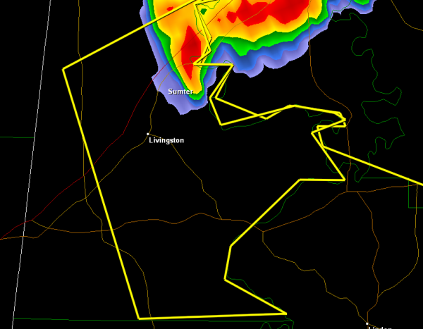
THE NATIONAL WEATHER SERVICE IN BIRMINGHAM HAS ISSUED A
* SEVERE THUNDERSTORM WARNING FOR…
SUMTER COUNTY IN WEST CENTRAL ALABAMA…
* UNTIL NOON CDT
* AT 1118 AM CDT…THE NATIONAL WEATHER SERVICE INDICATED A SEVERE
THUNDERSTORM CAPABLE OF PRODUCING QUARTER SIZE HAIL…AND DAMAGING
WINDS IN EXCESS OF 60 MPH. THIS STORM WAS LOCATED NEAR EPES…OR 7
MILES NORTHEAST OF LIVINGSTON…AND MOVING SOUTHEAST AT 30 MPH.
* LOCATIONS IMPACTED INCLUDE…
LIVINGSTON…THE UNIVERSITY OF WEST ALABAMA…BLUFFPORT…
COATOPA…DUG HILL…UNIVERSITY OF WEST ALABAMA…LILITA AND
BELLAMY.
THIS INCLUDES…
INTERSTATE 20 EXIT NUMBERS 17 THROUGH 23…
PRECAUTIONARY/PREPAREDNESS ACTIONS…
FOR YOUR PROTECTION…MOVE TO AN INTERIOR ROOM ON THE LOWEST FLOOR OF
YOUR HOME OR BUSINESS.
Category: Alabama's Weather, Severe Weather
About the Author (Author Profile)
Subscribe
If you enjoyed this article, subscribe to receive more just like it.


