Scattered Showers and Storms Persist
Over the course of the afternoon, the heaviest rain has been over eastern areas of the state. Currently portions of Randolph, Clay, Cleburne, Calhoun and Cherokee Counties are experience the more intense rain. These areas have seen several inches of rain today and several areal flood advisories are in effect. The rain has tapered off across southern portions of the state, but ample moisture continues to stream north from the Gulf. We can expect to see additional showers and thunderstorms during the overnight hours.
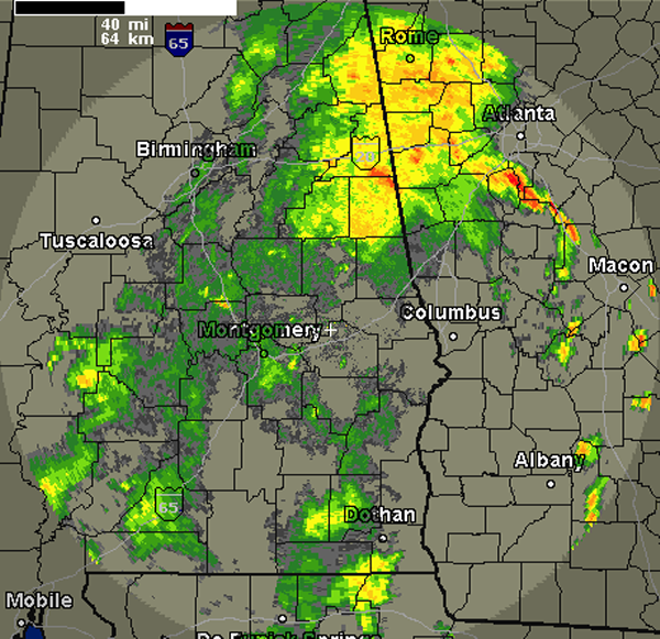
Most areas should see descent rain chances again for Sunday, before conditions begin to improve and become more typical for this time of year, just in time to start a new work week. With all the rain that has fallen the last several days, river flooding will become a significant threat. This afternoon rainfall runoff has caused Gate Operations to Begin at Lake Martin on the Tallapoosa River.
…GATE OPERATIONS HAVE BEGUN…
ALABAMA POWER COMPANY ADVISES THAT GATE OPERATIONS HAVE BEGUN AT
MARTIN DAM. THERE IS NOW ONE GATE OPEN.
INTERESTS DOWNSTREAM OF MARTIN DAM SHOULD STAY INFORMED OF REVISED
RIVER FORECASTS FOR THE LOWER TALLAPOOSA AND ALABAMA RIVERS.
Category: Alabama's Weather
About the Author (Author Profile)
Macon, Georgia Television Chief Meteorologist, Birmingham native, and long time Contributor on AlabamaWX. Stormchaser. I did not choose Weather, it chose Me. College Football Fanatic. @Ryan_StinnetSubscribe
If you enjoyed this article, subscribe to receive more just like it.


