More Heavy Downpours
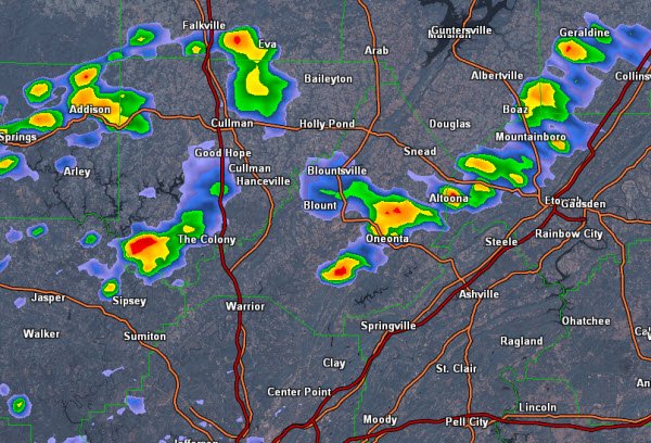
There have been a few heavy showers and storms that have developed across some of our northern counties this afternoon. The main threat with this activity remains flash flooding. The NWS has issued an areal flood advisory for portions of Blount County this afternoon as heavy rainfall has been falling across the county that could cause flooding in areas that flood easily as well as small streams that could rise rapidly.
There are also showers and storms across portions of Winston, Cullman and Etowah Counties. These storms could produce issues with flooding over the next few hours as most of the activity is slowly dropping south this afternoon.
THE NATIONAL WEATHER SERVICE IN BIRMINGHAM HAS ISSUED AN
* URBAN AND SMALL STREAM FLOOD ADVISORY FOR MINOR FLOODING OF POOR
DRAINAGE AREAS IN…
EASTERN BLOUNT COUNTY IN ALABAMA…
THIS INCLUDES THE CITIES OF…ONEONTA…CLEVELAND…
* UNTIL 345 PM CDT
* AT 150 PM CDT RADAR INDICATED OVER ONE INCH OF RAIN HAD FALLEN IN
A VERY SHORT DURATION OVER CENTRAL BLOUNT COUNTY. THIS STORM WILL
MOVE SLOWLY SOUTHWARD THROUGH ONEONTA AND COULD RESULT IN MINOR
AND LOCALIZED FLOODING.
PRECAUTIONARY/PREPAREDNESS ACTIONS…
A FLOOD ADVISORY MEANS RIVER OR STREAM FLOWS ARE ELEVATED OR PONDING
OF WATER IN URBAN OR OTHER AREAS IS OCCURRING OR IS IMMINENT.
Category: Alabama's Weather
About the Author (Author Profile)
Macon, Georgia Television Chief Meteorologist, Birmingham native, and long time Contributor on AlabamaWX. Stormchaser. I did not choose Weather, it chose Me. College Football Fanatic. @Ryan_StinnetSubscribe
If you enjoyed this article, subscribe to receive more just like it.


