Tropics are Active
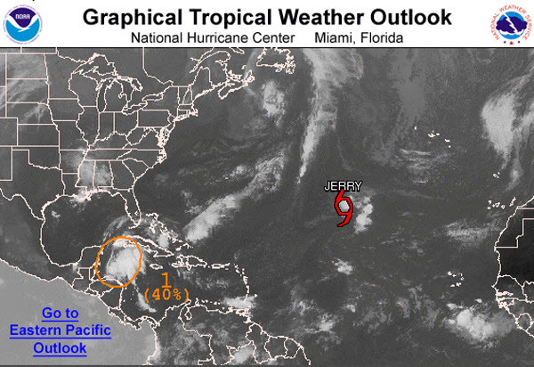
Today, Tropical Storm Jerry continues to meander across the Central Atlantic and remains no threat to any land areas and is what we call a fish storm. A fish storm is a storm that only impacts the fish. Latest data on Jerry, keeps him as a minimal tropical storm and nearly stationary.
SUMMARY OF 1100 AM AST…1500 UTC…INFORMATION
———————————————–
LOCATION…28.2N 43.9W
ABOUT 1185 MI…1910 KM WSW OF THE AZORES
ABOUT 1275 MI…2055 KM E OF BERMUDA
MAXIMUM SUSTAINED WINDS…40 MPH…65 KM/H
PRESENT MOVEMENT…STATIONARY
MINIMUM CENTRAL PRESSURE…1009 MB…29.80 INCHES
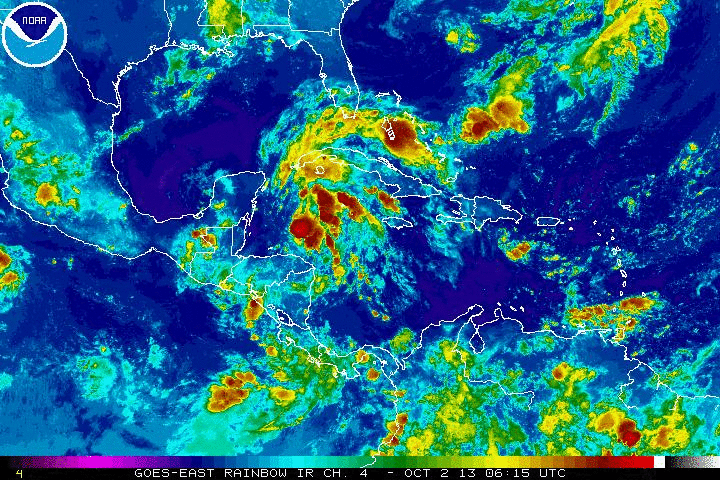
More importantly, we are keeping a close eye on an area of unsettled weather in the western Caribbean today. This feature is becoming better organized and looks as though it could impact areas of the Gulf Coast and Southeast this weekend. Over the next 48 hours the National Hurricane Center gives this area of disturbed weather a 40% chance of developing into a tropical cyclone. If it does develop, the next name on the list is Karen.
This area appears to be getting better organized and but as it heads into the southern Gulf of Mexico it will encounter an area of wind shear that will limit development in the short term. It will continue a northwestward track the next couple of days, but as a cold front continues to head towards the Gulf Coast this weekend, the front is expected to cause this area of disturbed weather be pulled up towards the northeastern Gulf Coast this weekend. It could be quite the rain maker for portions of the Southeast this weekend. Still plenty of time to monitor this entity, but expect some sort of impact on the U.S., most noticeably with very heavy rainfall.
Category: Tropical
About the Author (Author Profile)
Macon, Georgia Television Chief Meteorologist, Birmingham native, and long time Contributor on AlabamaWX. Stormchaser. I did not choose Weather, it chose Me. College Football Fanatic. @Ryan_StinnetSubscribe
If you enjoyed this article, subscribe to receive more just like it.


