Big Rain Event Ahead; Some Sleet As It Begins
An all new edition of the ABC 33/40 Weather Xtreme video is available in the player on the right sidebar of the blog. You can subscribe to the Weather Xtreme video on iTunes by clicking here.
BIG WETDOWN AHEAD: Clouds are increasing quickly across Alabama this morning ahead of a major storm system that promises to bring a big rain event to our state, and create big Thanksgiving travel problems for the eastern part of the U.S.
SOME SLEET TODAY: Precipitation will break out across the state this afternoon, and with a cold, dry airmass in place, there is a good chance it begins as sleet (ice pellets). This won’t create any issues with temperatures well above freezing, and the sleet will change over to all rain pretty quickly. Sleet rarely causes many problems, even in a colder airmass.
So, don’t freak out if you see sleet falling today. Those that don’t read our blog and use “crap apps” probably won’t know… just calm them down.
SOAKING RAIN: The guys are WPC are printing around 3 inches of rain for this part of Alabama tonight and tomorrow…
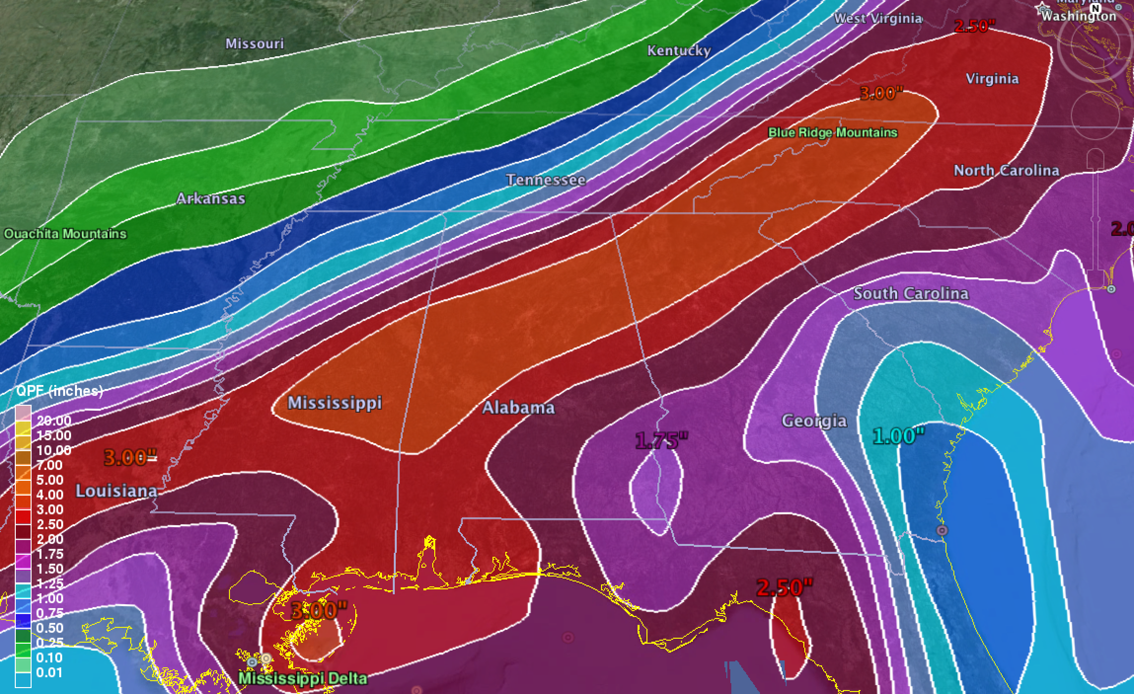
We figure most communities will see 2 to 3 inches of rain as a surface low passes just the the south. It will be a cold rain; temperatures will hold in the 40s all day tomorrow, so no severe weather or thunder. Just lots of rain. Probably not enough for any flooding issues since we have been relatively dry lately.
The high resolution NAM shows the heavier rain tapering off by midday tomorrow, but light rain is likely into the afternoon.
SNOW FLAKES ARE POSSIBLE: As the surface low pulls away to the northeast, another surge of cold air will move into Alabama Wednesday. And, there is a decent chance the rain will change to light snow before ending very early Wednesday morning.
I doubt if there is much accumulation, but some grassy areas, especially over Northeast Alabama, might see a dusting. The best chance of snow will come from about midnight tomorrow night until 5:00 a.m. Wednesday, so there is a decent chance you will sleep through it if we do see a few snow flakes. Don’t expect snow to be a problem for roads. But…
ICY SPOTS? Remember we are expecting 2 to 3 inches of rain, and I am pretty confident there will be some spots of standing water on bridges and overpasses early Wednesday morning, and with temperatures dropping into the 20s, some of this could freeze, and there could be some slick spots. So, if you are driving early Wednesday, just watch for “black ice” issues where water is still standing. Don’t think this will be a widespread issue, but you need to be aware of the potential.
Wednesday will be windy and cold with a clearing sky; we won’t get of out the 30s, and a strong northwest wind of 15-25 mph will make it feel colder.
THANKSGIVING DAY: Thursday morning will be very cold. The GFS is printing a low of 22 degrees for Birmingham, many colder valley locations across North and Central Alabama will start the day in the teens. The day will be sunny with a high in the mid 40s.
BLACK FRIDAY: Again, a cold morning. Early morning shoppers will need to bundle up as we begin the day in the 20s; the high will be in the low 50s with a good supply of sunshine.
IRON BOWL: The weather continues to look excellent in Auburn Saturday. The sky will be partly to mostly sunny at kickoff (2:30p CT), with a temperature at Jordan-Hare Stadium near 58 degrees, cooling down into the low 50s by the fourth quarter. No chance of rain, a really great day for a really great game.
OUR WEEKEND: We stay dry here Saturday and Sunday; the high will be in the upper 50s both days with a decent amount of sunshine through scattered clouds.
Looks like wet weather returns to Alabama early next week. See the Weather Xtreme video for details.
WEATHER BRAINS: Don’t forget you can listen to our weekly 90 minute netcast anytime on the web, or on iTunes. This is the show all about weather featuring many familiar voices, including our meteorologists here at ABC 33/40. We will produce this week’s show at 8:30 CT tonight; you watch watch it on “James Spann 24/7” on cable systems around the state, or on the web here.
CONNECT: You can find me on all of the major social networks…
Facebook
Twitter
Google Plus
Instagram
I will be doing a weather program this morning at Cullman East Elementary… look for the next Weather Xtreme video here by 4:00 this afternoon. Enjoy the day!
Category: Alabama's Weather
About the Author (Author Profile)
James Spann is one of the most recognized and trusted television meteorologists in the industry. He holds the AMS CCM designation and television seals from the AMS and NWA. He is a past winner of the Broadcast Meteorologist of the Year from both professional organizations.Subscribe
If you enjoyed this article, subscribe to receive more just like it.


