Rain Has Returned, Temps Remain Above Freezing
As expected, widespread showers and even a few thunderstorms have returned to Alabama tonight. Much more precip has developed over Mississippi and is lifting towards the east-northeast. Some of the heavier rain is currently falling across portions of Fayette, Lamar, Winston, Walker, and Marion Counties in northwestern areas of the state. Rain will continue to develop and spread east overnight and a soaking rain is on tap for Alabama again tonight.
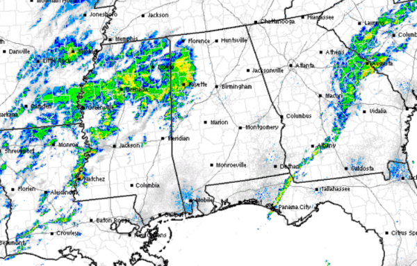
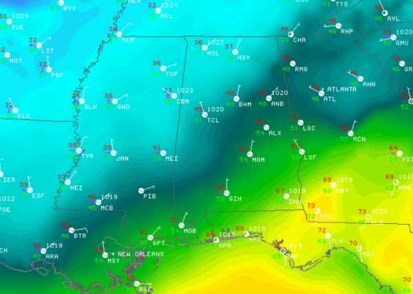
Now to the all important temperatures readings across the state. At last check, all locations across Alabama are above freezing. Any precip that is currently falling is a very cold rain. There is a range in temps depending on you location; locations along the Interstate 59 corridor are in the mid 40s, south of there 50s are the predominant observations. The trick is across northwestern portions of the state. Temperatures are in the mid-30s already and will drop very slowly overnight. For this reason, counties across the Tennessee Valley of Alabama and northern portions of Mississippi are under winter weather advisories as well as a freezing rain advisory.
There are some reports via social media of some sleet mixing in with rain across northern Mississippi. The roads will remain fine until surface temps drop below freezing, which is not expected until early tomorrow morning.
Category: Alabama's Weather
About the Author (Author Profile)
Macon, Georgia Television Chief Meteorologist, Birmingham native, and long time Contributor on AlabamaWX. Stormchaser. I did not choose Weather, it chose Me. College Football Fanatic. @Ryan_StinnetSubscribe
If you enjoyed this article, subscribe to receive more just like it.


