Warming Trend Ahead
An all new edition of the ABC 33/40 Weather Xtreme video is available in the player on the right sidebar of the blog. You can subscribe to the Weather Xtreme video on iTunes by clicking here.
STILL COLD TONIGHT: Nice to see temperatures back in the 50s across Alabama this afternoon with sunshine in full supply; Tuscaloosa reached 60 degrees at 2:00. But, once the sun goes down, it will be cold again tonight and we a low in the 30-35 degree range early tomorrow for most communities.
MID-WEEK WARM-UP: The high tomorrow will be pretty close to 60; some risk we see a shot of slightly cooler air Wednesday that will knock highs back down into the 50s, but then we rise into the mid 60s Thursday afternoon. The sky will be sunny on all three of these days with dry air remaining in place.
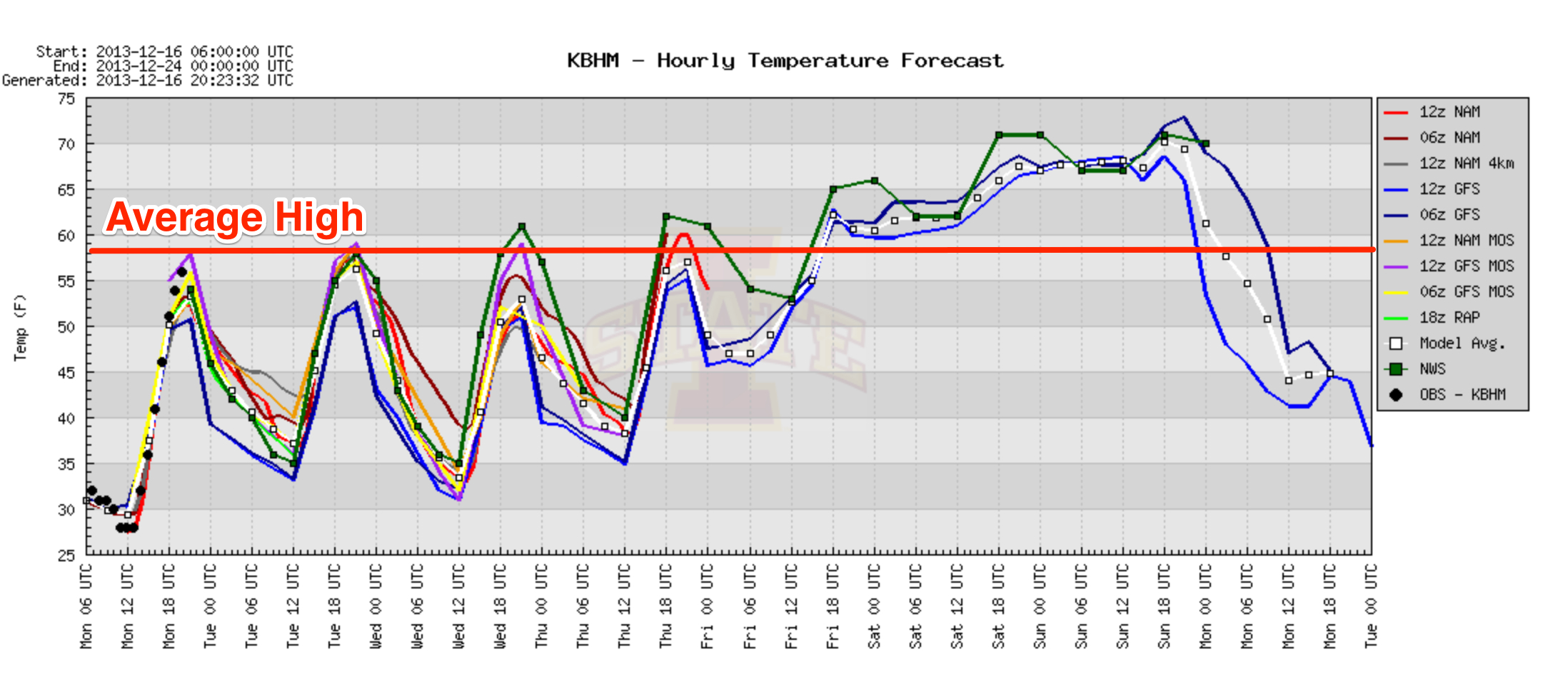
FRIDAY: Moisture returns with a good southerly breeze ahead of a developing storm system to the west. An upper low will open up into a wave and move into West Texas by Friday evening, and a surface low will form near Waco. While we might see a few showers around here Friday, they should be rather scattered in nature, and the sun could be out at times. The high Friday afternoon will be in the upper 60s.
STORMY WEEKEND: A warm front extending eastward from the Texas low is expected to move through Alabama Friday night and Saturday morning… this should bring a good round of rain, and possibly a few thunderstorms, to the state as the weekend begins. The 12Z GFS pushes the warm front north of here Saturday afternoon, and there could be a break in the rain at that time with a little sun breaking through. The high Saturday will be in the low to mid 70s; the record high for December 21 is 73 set in 1923, and that record could be in danger.
SEVERE WEATHER THREAT? The surface low moves from near Waco, Texas Friday to Little Rock, Arkansas Saturday evening, and on to near Buffalo, New York Sunday. With Alabama being in the warm sector of the storm, and with good support from an upper trough to the west, that will open the door for the potential of strong to severe thunderstorms across Alabama late Saturday night or Sunday.
The low level jet (around 5,000 feet off the ground) is expected to exceed 65 knots, low level bulk shear is very high (over 40 knots from the surface to 925 mb), and surface dew points are expected to reach the 60s. This clearly suggests some risk of severe weather.
Using a blend of model output, seems like the main 12 hour severe weather threat over the weekend will come from midnight Saturday night through 12:00 noon Sunday. Hopefully, if the storms come through during the early morning hours when the air tends to be more stable, that will mitigate the severe weather threat to some degree, but we simply don’t know at this point.
It is too early to determine the magnitude of the severe weather threat, or to identify the specific modes of severe weather we will deal with. We will have a good idea by Wednesday morning. Stay tuned.
Rain amounts of 2-3 inches are possible over the weekend with very high precipitable water values.
CHRISTMAS WEEK: Monday will be windy and colder as the sky becomes mostly sunny. Not sure we can get out of the 40s Monday afternoon. Then, for Tuesday and Christmas Day, the weather looks cool and dry with a good supply of sunshine both days. The low early Christmas morning will be in the 30s, followed by a high in the 50s. Right at seasonal average values for late December in Alabama.
READY FOR MORE DAYLIGHT? The winter solstice is this Saturday at 11:11 a.m. CST. It is our “shortest day” of the year in terms of the number of daylight hours… the amount of daylight will begin to increase by a minute or two a day next week.
WEATHER BRAINS: Don’t forget you can listen to our weekly 90 minute netcast anytime on the web, or on iTunes. This is the show all about weather featuring many familiar voices, including our meteorologists here at ABC 33/40.
CONNECT: You can find me on all of the major social networks…
Facebook
Twitter
Google Plus
Instagram
Look for the next Weather Xtreme video here by 7:00 a.m. tomorrow…
Category: Alabama's Weather
About the Author (Author Profile)
James Spann is one of the most recognized and trusted television meteorologists in the industry. He holds the AMS CCM designation and television seals from the AMS and NWA. He is a past winner of the Broadcast Meteorologist of the Year from both professional organizations.Subscribe
If you enjoyed this article, subscribe to receive more just like it.


