

Severe Storms Crossing the Mississippi River

The more intense storms are currently crossing the Mississippi River into Mississippi and western Tennessee. The storm are moving to the east rapidly and are producing very gusty winds, torrential rainfall and are bringing with them the threat of damaging winds, tornadoes, and flooding.
Numerous severe thunderstorm warnings and flash flood warnings are accompanying these storms. Even some tornado warnings mixed in with the main line. Areas outlined in yellow are under a tornado watch, orange polygons severe thunderstorm warnings, red polygons are tornado warnings, and green and maroon are flooding and flash flooding.
Across Alabama currently, a few showers have developed and are currently east of Interstate 65. These showers are racing off to the north with the low-level jet. For the next few hours, we certainly could see showers develop at anytime. As the line of storms and better uplift begin to move closer to the state, we are likely to see some thunderstorm development ahead of the main line. We will have to watch these storms carefully if the do develop.
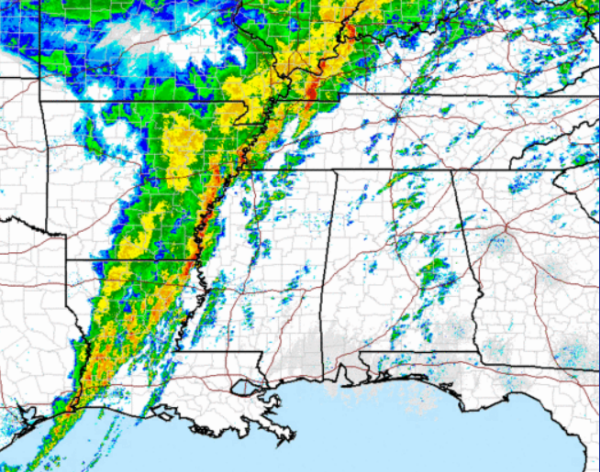
The SPC maintain much of Alabama in a slight risk for severe weather tonight, with an area of northwestern Alabama in an enhanced moderate risk. Strong and severe storms will move into the the state over the next several hours. We are expecting the SPC to issue some sort of watch as these storms move closer to the state. Stay weather aware overnight as severe storms with damaging straight line winds and tornadoes will be possible.
Category: Alabama's Weather, Severe Weather
About the Author (Author Profile)
Macon, Georgia Television Chief Meteorologist, Birmingham native, and long time Contributor on AlabamaWX. Stormchaser. I did not choose Weather, it chose Me. College Football Fanatic. @Ryan_StinnetSubscribe
If you enjoyed this article, subscribe to receive more just like it.


