Numbers
The BMX Sounding at 6 p.m showed an airmass that is slightly more unstable than we might have thought.
Here are some numbers and commentary:
TEMPS/MOISTURE
Plenty of moisture in place with dewpoints in the 65F to 67F range in the I-20 corridor. Temperatures rage from 73F at Anniston and Birmingham to 76F at Tuscaloosa.
INSTABILITY
Surface based CAPE Value at BMX was 819 j/kg. We had thought it to be less than 500 j/kg. This gives the system a little more octane. Lifted Index was -4C which is moderate. Low level lapse rates are marginal, while mid level lapse rates are more robust.
CAP
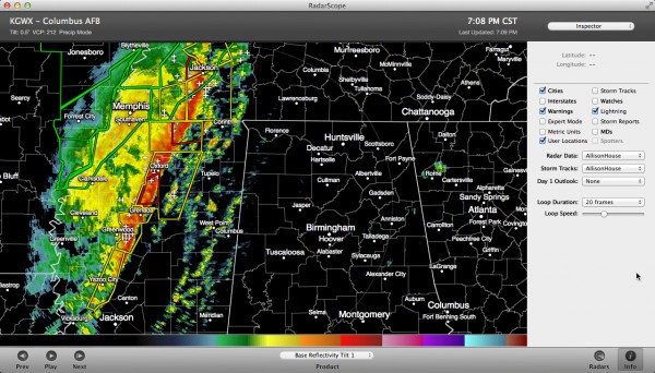
There is a small remaining cap over Central Alabama, but that certainly won’t cause any problems for the approaching squall line. Developing cells over eastern Mississippi indicate the cap is already broken there.
BULK SHEAR
0-6km speed shear is 57 knots. Plenty sufficient for organized updrafts.
STORM RELATIVE HELICITY
349 m2/s2 is plenty sufficient for supercells to develop. This number increases the further you go north.
STP (SIGNIFICANT TORNADO PARAMETER)
2.2 at Birmingham. This is concerning. While not off the scale, it is sufficient for a couple of significant tornadoes.
PRECIPITABLE WATER
1.68 inches: This is in the 99th percentile for late December and nearly a record. This means there will be plenty of heavy rain. Fortunately, the system is moving fairly quickly, so flooding will not be a major concern except in localized areas. Expect a few flash flood warnings though.
SUMMARY
Of course, instability values should slowly decrease, but the loss of heating could be offset by continued advection of warm, moist air. The wind fields will slowly decrease as the dynamics track further to the north overnight.
We will watch those showers over eastern Mississippi to see if they can develop into thunderstorms. They would certainly rotate and could produce damaging winds and a couple of tornadoes. The main line will produce several reports of wind damage and could have embedded tornadoes as well.
We will have frequent updates all night.
Category: Alabama's Weather, Severe Weather


