

Cold, Raw Monday; Brighter Tomorrow
An all new edition of the ABC 33/40 Weather Xtreme video is available in the player on the right sidebar of the blog. You can subscribe to the Weather Xtreme video on iTunes by clicking here.
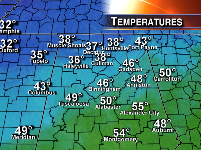
COLD LATE DECEMBER DAY: Many communities across North Alabama won’t be getting out of the 30s this afternoon thanks to cold air advection and a cloud cover.
We see just a few sprinkles on radar over East Alabama, and a few snow flurries over far North Alabama, but most places are dry despite the clouds.
The sky will clear tonight, and most communities will begin the day tomorrow in the 25-30 degree range.
MID-WEEK: Tomorrow will be a brighter day with sunshine returning. While we start the day below freezing, the high will be in the upper 40s. Below the average of 53, but for many it will be warmer than today.
We expect a high in the mid 50s Wednesday… clouds will begin to increase Wednesday afternoon ahead of the next wet weather system to impact Alabama.
WEDNESDAY NIGHT/THURSDAY: Looks like the main 24 hour window for rain will come from about 3:00 a.m. until 3:00 p.m. Thursday. An rather robust upper trough, combined with an approaching cold front, will bring rain back to the state. The air will be cool and stable, so no severe weather and no thunder… just periods of rain. Rain amounts of around 1/2 inch are likely over North/Central Alabama, with totals close to one inch over the southern counties of the state.
And, as the rain moves out Thursday afternoon, colder air moves in. I would not be surprised if parts of North Alabama fall into the 30s. Might even see a few snow flakes Thursday over Arkansas and Tennessee, but no serious accumulation is expected there.
MORE COLD AIR: Friday will be a cold day. We start the day well down in the 20s, and the high will be only in the upper 30s despite the return of sunshine. The coldest morning will come early Saturday, when most places will see a low between 18 and 23 degrees.
THE ALABAMA WEEKEND: After that cold start, we warm to near 50 degrees Saturday afternoon with a sunny sky. Sunday will also be mostly sunny with a high in the low 50s.
SUGAR BOWL WEATHER: For Alabama fans headed to New Orleans for the Sugar Bowl (Thursday night; 7:30p CT kickoff), the weather will be generally cloudy in New Orleans through Thursday. Just a few widely scattered showers today and tomorrow, becoming more widespread Wednesday and Thursday. Nothing too heavy, and no severe weather. Afternoon highs will be mostly in the 50s; colder and drier air arrives Friday with the sun finally breaking through. The high Friday will drop into the 40s.
BCS NATIONAL CHAMPIONSHIP WEATHER: For now it looks like routine southern California weather for Auburn fans making the trip out west. No rain for the next 7-10 days at Pasadena, CA; highs are in the 70s, with lows between 47 and 52. Lots of sun.
BBVA COMPASS BOWL: A perfect day for football in Birmingham Saturday, when Vanderbilt and Houston match up at 12:00 noon. Lots of sun; the kickoff temperature will be near 45 degrees, rising to near 50 by the final whistle. No risk of rain.
MAJOR ARCTIC OUTBREAK NEXT WEEK? The weather community is buzzing about the European global model (the ECMWF), suggesting record shattering cold by next Tuesday (January 7). But, the GFS is not as cold, and the Euro has had a cold bias this season. We note the ECMWF suggests a low in the -20 degree range around Nashville, with sub zero cold down into the Tennessee Valley of North Alabama. It is very hard to get numbers like that so far south with no snow cover.
I am not buying into the historic cold for now, but no doubt there is a chance we could see the coldest air so far this season by the first half of next week. See the Weather Xtreme video for the maps, graphics, and details. Just too early to be specific about how cold it gets around here.
THE LAND OF VOODOO: Snow lovers always love the voodoo charts in winter (forecast panels in the 7 to 15 day time frame), hoping to catch a good snow look. Quite frankly, I don’t see anything like that on the morning model runs, but if the Arctic shots keep coming, no doubt we might flirt with winter weather mischief at some point over the next 4-5 weeks.
WEATHER BRAINS: Don’t forget you can listen to our weekly 90 minute netcast anytime on the web, or on iTunes. This is the show all about weather featuring many familiar voices, including our meteorologists here at ABC 33/40. Our annual year ender is tonight at 8:30p CT… Greg Carbin of the Storm Prediction Center will go through the biggest weather events of 2013. You can watch it live on “James Spann 24/7” on cable systems around Alabama, or on the web here.
CONNECT: You can find me on all of the major social networks…
Facebook
Twitter
Google Plus
Instagram
Look for the next Weather Xtreme video here by 7:00 a.m. tomorrow….
Category: Alabama's Weather
About the Author (Author Profile)
James Spann is one of the most recognized and trusted television meteorologists in the industry. He holds the AMS CCM designation and television seals from the AMS and NWA. He is a past winner of the Broadcast Meteorologist of the Year from both professional organizations.Subscribe
If you enjoyed this article, subscribe to receive more just like it.


