A Late Night Forecast Update
Not much change in thinking tonight based on the evening model runs. I have posted the new 7 day package here, but will reprint the main part below.
SUNDAY SHOWERS: Our arctic front is to the northwest of us over Arkansas and there is a surface low south of Little Rock this morning. This surface low is poised to pull warm, Gulf air northward. Readings are in the 60s near Houston early this morning, while we are in the 30s in Central Alabama. By noon, 70s will be over southern Louisiana with 60s over southern Mississippi and coastal Alabama. 50s will be common over the rest of Alabama. A few showers started in the predawn hours over western Alabama and they will remain scattered across the area through the morning.
HERE COMES THE FRONT: Take these times with a grain of salt, sort of like waiting on the train. The front should reach northwest Alabama around 3-4 p.m. today. It should reach Jasper and Tuscaloosa by 5-6 p.m., Gadsden/Birmingham by 6-7 p.m. and Anniston/Montgomery by 7-8 p.m. It will be coming like a freight train, pulling some dramatic temperature drops in its wake.
FAST FREEZE AHEAD: You can expect a 25 degree temperature drop in the first five hours after frontal passage, including 6-8 degrees in the first hour and 15 degrees in the first two hours. The mercury should go below freezing within 3 hours of frontal passage. Based on current model data, this looks like freezing temps over West Alabama around 8-9 p.m., Birmingham around 9-10 p.m. and Anniston by 10-11 p.m.
PRECIPITATION: It appears that a band of solid precipitation will follow the frontal passage, and here in lies part of the rub. The duration of the precipitation should be sufficient for the surface temperature to drop below freezing before it ends, leading to a wintry mix of freezing rain, sleet and snow mixed. There could be sufficient accumulation for there to be slick spots on roads as soon as temperatures reach freezing. And even if there isn’t any accumulation of the sleet, snow or ice, the rapid temperature drop will allow residual moisture on roads and bridges to freeze into sheets of black ice that are virtually invisible to motorists.
SNOW ACCUMULATION PROSPECTS: As atmospheric temperature profiles turn quickly colder, any precipitation will turn over to all snow. Snow showers will continue through the overnight hours. Some spots could see a dusting to 1/2 inch in areas north of a line from Tuscaloosa to Alex City. One inch or more could fall over the Tennessee Valley. The very cold nature of the airmass could squeeze out more light snow showers through the day on Monday. Winter weather advisories may be required for Central Alabama if the wintry mix becomes heavy enough to cause travel problems.
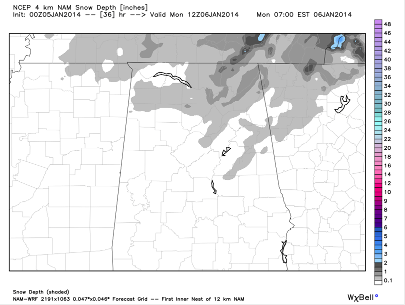
Here are the 0z NAM snowfall totals by Monday morning. The areas in light gray are a dusting to one half inch of snow. There are some one inch amounts over Northeast Alabama. These accumulations are generally consistent with the amounts we have been thinking.
DANGEROUS WIND CHILLS: On top of everything else, the cold front will be accompanied by winds of 20-30 mph with gusts to 40 mph through the overnight hours. Wind chills will be in the single digits within 4-6 hours of frontal passage and will go before zero overnight and stay there all day Monday and Monday night. Wind chill advisories are in effect through the day on Monday.
TEMPS: Lows tonight will be in the 10-15F range along the I-59 corridor, with readings around 8-10F to the northwest and north. Everything north of US-78 stays in the teens Monday during the day, with places like Tuscaloosa, Clanton and Alex City barely managing the lower 20s. Monday night will be the brutally cold night, with lows ranging between 6-10F in the I-59 corridor with single digits common to the north and northwest. To the south, lows across the rest of Central Alabama will range between 8-14F. Tuesday highs will remain below freezing all the way to Mobile. Lows Tuesday night will range between 14-18F across the entire area. A hard freeze warning is in effect until noon Tuesday.
SCHOOL DELAYS: Many school systems have already instituted delays for early Monday morning in anticipation of the very cold temperatures and wind chill values as well as the potential for slick spots on area roads. Unfortunately, things will not improve much during the day.
PREPARATIONS: Think about the four P’s as you ready for this event: People, Pets, Pipe and Plants. Make sure friends, family members and neighbors know about the coming cold and have sufficient heat. Check on elderly folks to make sure they have not ventured outside and fallen. Make sure pets have a warm place and that livestock have sufficient shelter. Make sure any pipes that are exposed to the cold air are sufficiently insulated. Allow water in these pipes to drip slowly to relieve pressure in case pipes do freeze. Protect vulnerable plants. Check antifreeze levels in vehicles.
WEDNESDAY WARM UP: We finally should go back above freezing across much of Central Alabama by noon Wednesday after some 62-65 hours below 32F. Highs will be in the lower 40s.
Category: Alabama's Weather, Winter Weather
About the Author (Author Profile)
Bill Murray is the President of The Weather Factory. He is the site's official weather historian and a weekend forecaster. He also anchors the site's severe weather coverage. Bill Murray is the proud holder of National Weather Association Digital Seal #0001 @wxhistorianSubscribe
If you enjoyed this article, subscribe to receive more just like it.


