Snow Day For Alabama
An all new edition of the ABC 33/40 Weather Xtreme video is available in the player on the right sidebar of the blog. You can subscribe to the Weather Xtreme video on iTunes by clicking here.
NO MAJOR FORECAST CHANGES: A long review of model data suggests no major changes are needed in our forecast this morning… just a few small adjustments.
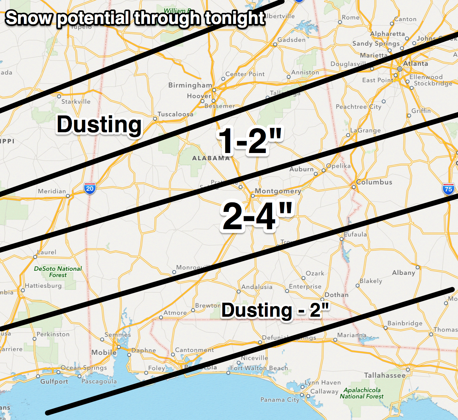
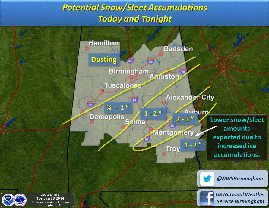
The NWS continues a winter storm warning for the southern half of the state, where snow amounts of 2 to 4 inches are possible, along with some ice from freezing rain. To the north, a winter weather advisory is in effect for these counties, where some light snow accumulation is possible… Sumter, Greene, Hale, Perry, Bibb, Chilton, Shelby, Talladega, Clay, Calhoun, Cleburne, and Randolph. (Cleburne and Calhoun were added to the advisory early this morning).
Here are the important points concerning today’s weather in Alabama…
*Snow begins this morning. Snow is likely just about statewide, but the snow should be light over the northern half of the state. A dusting is possible around Tuscaloosa, Birmingham, and Gadsden, but no significant accumulation is expected, and no travel issues are expected. Anniston could see around 1/2 inch, and it is not out of the question that a slick spot of two could develop there, but again, nothing widespread is expected for now. Calhoun County has been added to the Winter Weather Advisory for this reason.
*The best chance of accumulating show is south of a line from Eutaw to Greensboro to Centreville to Calera to Talladega to Anniston and Heflin. But the really big snows will come along and south of U.S. 80, in the Winter Storm Warning area. Some places between Montgomery and Dothan could see 4 inches of snow by tonight.
*Closer to the coast, precipitation begins in the form of rain and sleet, changing to freezing rain, and then snow before ending. Still, Mobile could see one inch of snow before it is all over. Even some light accumulation is possible right on the beach at Gulf Shores.
*We don’t expect enough ice accumulation over South Alabama for widespread power outages at this point.
*In terms of timing, some slick spots could develop in the 10:00-12:00 noon time frame over Central Alabama counties in the Winter Weather Advisory as the snow falls. While the issues are not expected to be widespread there, be careful when driving today. Strong north winds will limit the accumulation on roads.
*Travel will become difficult across the southern half of Alabama late this afternoon and tonight due to bridge icing. Some black top roads could become icy and dangerous as well. Most South Alabama schools are closed today and tomorrow. Auburn University, Troy University, the University of South Alabama, and the University of West Alabama are all closed today.
*The snow will end tonight, and sunshine returns in full force tomorrow, but we stay very cold with a high only in the low to mid 30s.
IMPORTANT POINT: We have limited skill in dealing with a South Alabama snow/ice event since they just don’t happen often, so expect a few surprises. And, as is the case with every Alabama winter storm event, some people will be delighted with the amount of snow they see, and others severely disappointed. Keep an eye on the blog today as we watch radar trends and the event unfolds.
ARCTIC COLD: Aside from the snow, the big story is the cold. We will drop into the 8 to 13 degree range early tomorrow morning, and in the 10 to 15 degree range at daybreak Thursday. We finally begin a warming process Thursday afternoon with a sunny sky and a high in the low 40s.
FRIDAY AND THE WEEKEND: We hit the low 50s Friday with a mix of sun and clouds. Then over the weekend, we will deal with a risk of showers, especially Saturday afternoon, Saturday night, and early Sunday. Drier air returns Sunday afternoon with a clearing sky. The high Saturday will be close to 60, then falling back into the 50s Sunday.
Next week we will have a rain/storm event at mid-week; see the Weather Xtreme video for the maps, graphics, and details.
WEATHER BRAINS: Don’t forget you can listen to our weekly 90 minute netcast anytime on the web, or on iTunes. This is the show all about weather featuring many familiar voices, including our meteorologists here at ABC 33/40. Scroll down for the show notes on the new episode we recorded last night.
CONNECT: You can find me on all of the major social networks…
Facebook
Twitter
Google Plus
Instagram
I have a weather program this morning at Northside Middle School in Tuscaloosa County… look for the next Weather Xtreme video here by 4:00 this afternoon. Enjoy the day and stay tuned for updates…
Category: Alabama's Weather
About the Author (Author Profile)
James Spann is one of the most recognized and trusted television meteorologists in the industry. He holds the AMS CCM designation and television seals from the AMS and NWA. He is a past winner of the Broadcast Meteorologist of the Year from both professional organizations.Subscribe
If you enjoyed this article, subscribe to receive more just like it.


