

New NAM Model Data
The morning run of the North American Mesoscale model is in and here are some notes:
…shows best snow accumulations 1/2-2 inches with some 2-4 inch amounts in a 40-50 mile wide band stretching south from Russellville to Hartselle to Scottsboro southward to a line from Millport to Adamsville to Leeds to south of Oxford.
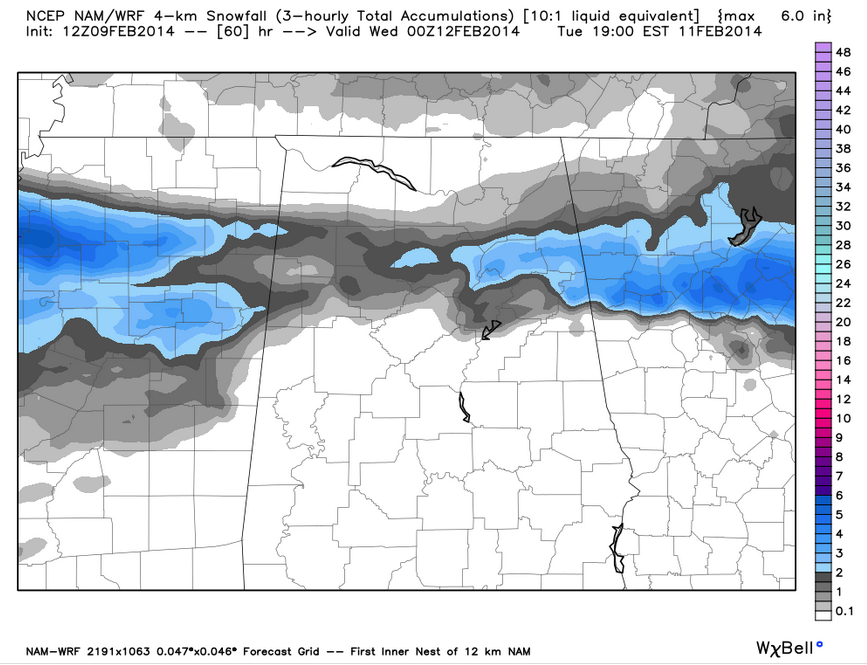
…even in this area, there will likely be a mix of freezing rain and sleet as well, especially along the southern periphery.
…temperatures will reach freezing just south of this band in an area with 3 hour precipitation amounts of 0.10-0.25. This could result in a serious glaze of ice from northern Pickens through Tuscaloosa, Jefferson, down into southern St. Clair, northern Talladega, Clay and Randolph Counties.
…the Birmingham model sounding for 6 a.m. Tuesday shows temperatures right at or just above freezing at the surface with readings just above freezing to about 700 millibars or 10,000 feet. This point to the threat of freezing here if that materializes.
…things improve as you move to the south a little, with surface temperatures in the middle 30s.
…interestingly, this model run backs off on the idea of snow for the Tennessee Valley Counties of North Alabama.
We caution that this is just one model run. Just one tool to help us hone in on an accurate concept of what the atmosphere will do.
The bottom line is that a winter storm will affect Alabama Monday night and Tuesday with a variety of frozen and freezing precipitation. Confidence is high that a mix of snow, sleet and freezing rain will affect parts of the area with significant impacts to travel. Resolving where those impacts will occur is the challenge.
Category: Alabama's Weather, Winter Weather
About the Author (Author Profile)
Bill Murray is the President of The Weather Factory. He is the site's official weather historian and a weekend forecaster. He also anchors the site's severe weather coverage. Bill Murray is the proud holder of National Weather Association Digital Seal #0001 @wxhistorianSubscribe
If you enjoyed this article, subscribe to receive more just like it.


