

Precipitation Moving into West Alabama
Conditions are going downhill tonight to the west of Alabama. Here are some late developments:
NWS JACKSON
…Heavier precipitation is spreading into the Jackson area at this time with temperatures in the 31-33F. The NWS warns that significant icing of bridges and overpasses will occur quickly.
…They have extended the Winter Storm Warning back through Natchez and into extreme northeastern Louisiana.
…The Jackson area is now under a Winter Storm Warning.
…0.10″ of ice at Hazehurst on exposed surfaces. Icicles starting to form.
…0.10″ of sleet in Winona.
…0.10″ of freezing rain at Clinton.
…Numerous reports of freezing rain across Madison Co, MS.
…Accumulating snow in Grenada.
…1.0 inch of snow in Greenville.
…1.4 inch of freezing rain at Winnsboro LA.
NWS SHREVEPORT
…Several cars stranded on the ramp from LA-3132 to I-20W in Shreveport from freezing rain.
…0.30″ of freezing rain fell earlier in Shreveport.
…Numerous reports of power outages around Shreveport/Bossier and around Longview TX.
FOR US HERE IN ALABAMA
…Moderate precipitation (rain and sleet) is moving into Pickens and Lamar Counties. It will move into fayette, Marion and Walker Counties.
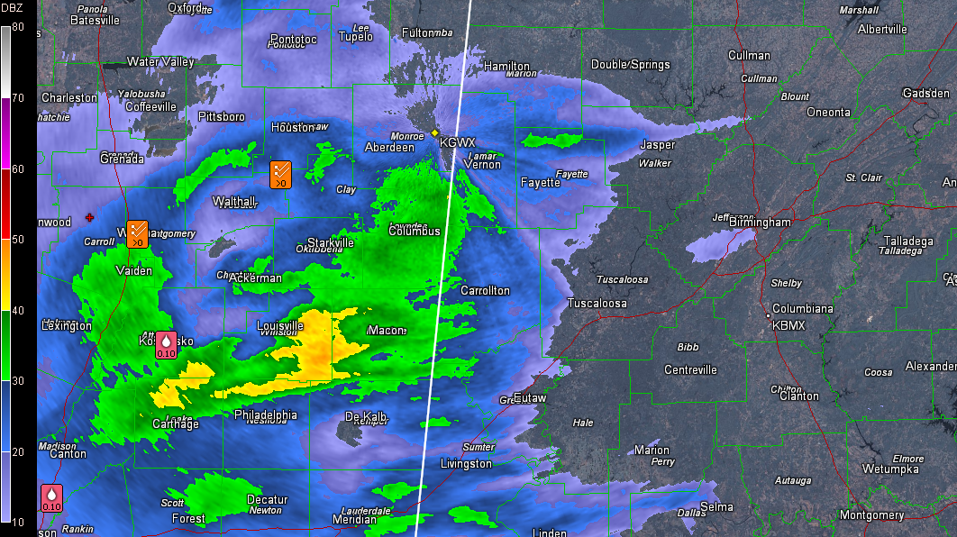
Temperatures are 32-34F north of I-22, including 32F at Haleyville. There will even be a little additional cooling as the precipitation saturates the low levels of the atmosphere and temperatures at or below freezing. Folks in Marion, northern Lamar and Winston Counties up into the Huntsville area should expect a wintry mix of freezing, sleet and freezing rain over the next few hours. To the and south and southeast, where it is a little warmer, it will be a cold rain, with some patchy bridge and overpass icing later.
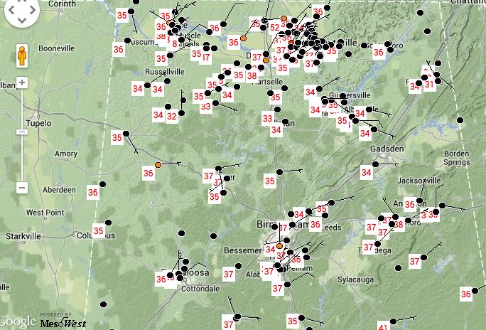
Temperatures will fall a few more degrees tonight, presenting the threat of freezing rain in the I-20 corridor especially around Birmingham. Concern is growing that this is a real possibility.
A Winter Storm Warning remains in effect for Blount, Calhoun, Cherokee, Cleburne, Etowah, Jefferson, Marion, St. Clair, Walker, Winston, Clay, Randolph, Shelby and Talladega Counties. Everyone in these counties should try to avoid travel tonight and tomorrow morning. If you must travel, you must check the latest road conditions and weather reports.
A Winter Weather Advisory is in effect for Fayette, Lamar, Bibb, Chambers, Chilton, Coosa, Tallapoosa and Tuscaloosa Counties. Icing is possible in these areas overnight, especially on bridges and overpasses.
This system has been full of surprises. Let’s hope it doesn’t have many more up its sleeve for Alabama.
Category: Alabama's Weather, Winter Weather
About the Author (Author Profile)
Bill Murray is the President of The Weather Factory. He is the site's official weather historian and a weekend forecaster. He also anchors the site's severe weather coverage. Bill Murray is the proud holder of National Weather Association Digital Seal #0001 @wxhistorianSubscribe
If you enjoyed this article, subscribe to receive more just like it.


