

Starting to Get Icing Reports from East Alabama
Freezing rain beginning to accumulate across Cleburne County.
Reports of trees weighted down with ice and decks iced over at Muscadine in Cleburne County.
Freezing rain is beginning to accumulate at Wedowee in Randolph County.
Weather stations in the area indicate temperatures are hovering around 33F at places like Heflin and Saks and Barfield and Shoal Creek. It was 32F at last report in Ashland in Clay County.
Most of the precipitation in that area has moved into Georgia, but more is building back over West Central Alabama and will move into that area this afternoon. Precipitation is also increasing back over the Delta counties of Mississippi and we will see that later today as well.
Up in Northeast Alabama, it is 31F in Rainsville with freezing rain sticking to cars.
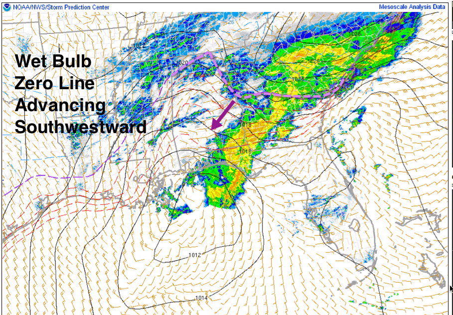
The wet bulb zero temperature will be something to continue watching today. It indicates areas where there is still room for evaporational cooling to lower the air temperature to the freezing mark. This WBZ line is now into East and Northeast Alabama. It is also present over Northwest Alabama. Temperatures that are above freezing in these areas will drop as precipitation moves in. This line continues pushing southwestward at around 25 miles an hour.
Scroll down for more forecast information. Be alert to an increasing threat for hazardous road conditions developing over eastern Alabama this morning and spreading southwestward through the day as colder air moves in aloft and at the surface. Snow will overspread the area this afternoon. You will want to be in place by 3 p.m. in the Birmingham area. Earlier to the east and northeast.
WILD MORNING AT CHEAHA
It would be wild to be atop Alabama’s highest peak right now. Just you can’t get there. From Tammy Power at Cheaha State Park “As you can tell by the SKYCAM we have yet to thaw. High winds continue and trees are down now. Power is out with ice on roads. This is not pretty. This is dangerous people must not visit. Falling trees could hurt people. Park closed. We were ready!”
#GEORGIAISCLOSED
I saw that hashtag on Twitter this morning. To the east, much of Central Georgia is iced in, but getting a temporary break as a lull in the precipitation occurs across their area. Steady snows continue across North Georgia however and should through the day.
Category: Winter Weather
About the Author (Author Profile)
Bill Murray is the President of The Weather Factory. He is the site's official weather historian and a weekend forecaster. He also anchors the site's severe weather coverage. Bill Murray is the proud holder of National Weather Association Digital Seal #0001 @wxhistorianSubscribe
If you enjoyed this article, subscribe to receive more just like it.


