

Seeing Rapid Transition to Frozen Precip
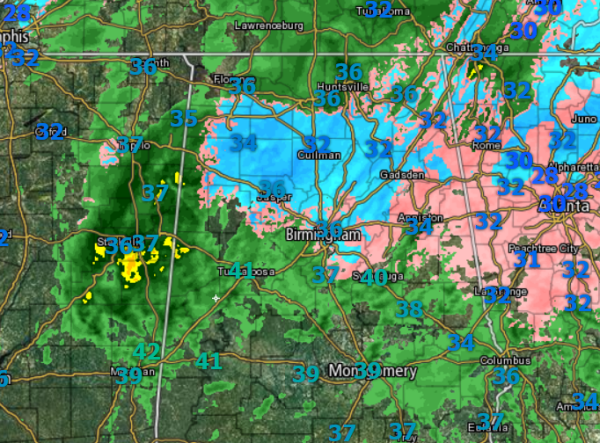
The rain is turning over to sleet and snow across the area. Via social media, it starts raining, then becomes a freezing rain and sleet mixture, and finally turns into snow. The radar image has changed rapidly the last hour as blue and pink, which are snow and a wintry mix, are taking the place of green which is mostly rain. We will continue to see the transition across Central Alabama through the afternoon.
Statement from NWS Birmingham:
Very dynamic situation ongoing here, as the low really starts spinning up in the Gulf. Looks like from surface analysis, the surface low is deepening about 1-2mb per hour, which is very quick deepening. Temps are cooling across the north, with laps soundings indicating that warm nose aloft quickly eroding due to that moistening aloft with dynamic cooling ongoing. We’ll have to just watch the radar from here on out to see where that heavier banding occurs where we get those heavier snowfall totals once the precip all changes over.
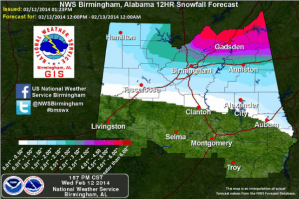
New projections for snowfall totals across Central Alabama. Once it starts snowing, it is expected to last for several hours. It will last into the evening and overnight hour and many locations are going to see an accumulation snow across the area.
Category: Alabama's Weather, Winter Weather
About the Author (Author Profile)
Macon, Georgia Television Chief Meteorologist, Birmingham native, and long time Contributor on AlabamaWX. Stormchaser. I did not choose Weather, it chose Me. College Football Fanatic. @Ryan_StinnetSubscribe
If you enjoyed this article, subscribe to receive more just like it.


