Rapid Changes
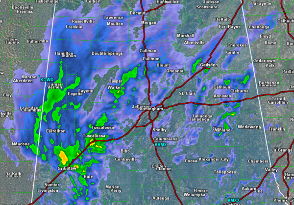
Reports are coming in so fast that they are hard to keep up with, but needless to say conditions and changing quickly.
A majority of our northern counties are seeing the snow fall. Along the I-20 corridor, we are seeing more reports of a rain/sleet mixture. This mixture will be short-lived as a continued transition to all snow is expected. In East Alabama, significant icing is ongoing for Cleburne and Randolph counties where there is an ice storm warning.
We are seeing a very rapid transition over to snow throughout Central Alabama. It appears it is taking about 30 minutes for the rain to transition through the freezing rain to sleet and then to snow. Quite the drastic change in precip across the area.
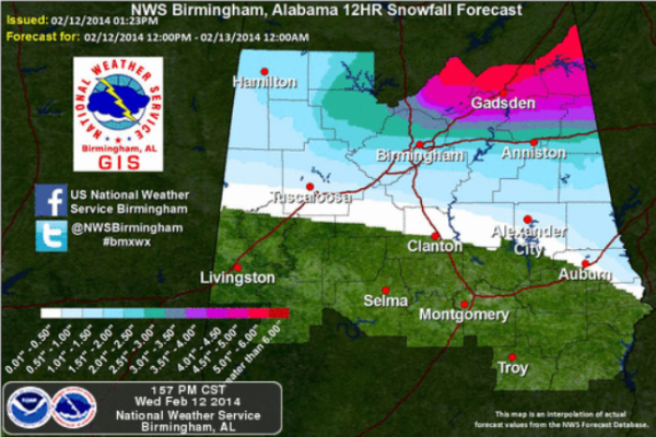
We are going to see snow through the rest of the afternoon, into the evening hours as well into the overnight hours. Expect accumulations throughout the area. Here is the overall projected snowfall accumulations from the National Weather Service, but as dynamic as this system is, there could certainly be a few areas that see some higher accumulations. Over the next few hours, we will likely see road conditions deteriorate and travel is not recommended once you see the transition to snow.
Category: Alabama's Weather, Winter Weather
About the Author (Author Profile)
Macon, Georgia Television Chief Meteorologist, Birmingham native, and long time Contributor on AlabamaWX. Stormchaser. I did not choose Weather, it chose Me. College Football Fanatic. @Ryan_StinnetSubscribe
If you enjoyed this article, subscribe to receive more just like it.


