

Heaviest Snow Lifting Northeast
It sure did get pretty exciting across Central Alabama this afternoon and evening. Once the rain started transitioning to snow, it happened quick and spread very rapidly.
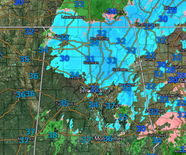
The heaviest band of snow developed over western portions of the state and moved east along the I-20 corridor where it produced convective snow burst. Intense snowfall rates over very short periods of time that caused travel conditions to deteriorate. This convective snow band produce intense snow throughout Central Alabama and turned everything white within a matter of minutes. It also produced several inches of snow very quickly
Social media was a buzz with such intense snowfall rates. I have see snowfall totals range from 1.5 to 6 inches across Central Alabama this evening.
Now the short-term forecast. With such intense snowfall, temps have fallen to at or just above the freezing mark along I-20. A look at the radar shows that for most areas along and west of I-65, the snow is done. We are see some rain and sleet into portions of Sumter, Greene, Hale, Marengo, and Perry Counties. The showers are south of the prime area for accumulations and should mostly cause wet roads in the area.
The heavier band that moved through the Birmingham Metro, continues to move east and is producing very heavy snowfall for areas east of Birmingham. Anniston, Gadsden, and Jacksonville are seeing the most intense snowfall rates currently.
To the north light to moderate snow is falling along the U.S. 278 corridor as well as locations across the Tennessee Valley of Alabama. The snow will continue to move east across this part of the state with additional accumulations expected.
For the rest of tonight, most of the snow is over with for much of Central Alabama. We could see a few snow showers through the night, but for the most part, any additional snow accumulations should be confined to eastern portions of the state, especially north of I-20 and east of I-65. For you overnight, temperatures will drop into the 20s in many locations as snow pack will allow this to happen. Road and travel conditions will not begin to improve tonight and it will be during the day Thursday before we see a drastic improvement in travel conditions.
Category: Alabama's Weather, Winter Weather
About the Author (Author Profile)
Macon, Georgia Television Chief Meteorologist, Birmingham native, and long time Contributor on AlabamaWX. Stormchaser. I did not choose Weather, it chose Me. College Football Fanatic. @Ryan_StinnetSubscribe
If you enjoyed this article, subscribe to receive more just like it.


