

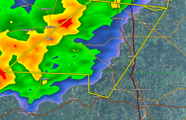
Severe Thunderstorm Warning Cullman County until 10 PM

The warning is for the extreme northwestern part of the county and will be affecting locations near Jones Chapel and West Point. This warning does not currently include the city of Cullman.
Area just to the north of U.S. 278 in the northwestern part of the county will be impacted, including location along State highway 157. Also heading north along I-65 and U.S 31 between Cullman and Huntsville will be affected by this storm.
THE NATIONAL WEATHER SERVICE IN HUNTSVILLE HAS ISSUED A
* SEVERE THUNDERSTORM WARNING FOR…
NORTHWESTERN CULLMAN COUNTY IN NORTH CENTRAL ALABAMA…
SOUTHEASTERN LAWRENCE COUNTY IN NORTHWEST ALABAMA…
SOUTHWESTERN MORGAN COUNTY IN NORTH CENTRAL ALABAMA…
* UNTIL 1000 PM CST
* AT 921 PM CST…DOPPLER RADAR INDICATED A LINE OF SEVERE
THUNDERSTORMS CAPABLE OF PRODUCING DAMAGING WINDS IN EXCESS OF 60
MPH. THESE STORMS WERE LOCATED ALONG A LINE EXTENDING FROM NEAR
TRINITY TO 8 MILES NORTH OF DOUBLE SPRINGS…AND MOVING EAST AT
50 MPH.
* LOCATIONS IMPACTED INCLUDE…
DECATUR…HARTSELLE…PRICEVILLE…FALKVILLE AND FLINT CITY.
PRECAUTIONARY/PREPAREDNESS ACTIONS…
SEVERE THUNDERSTORMS PRODUCE DAMAGING WINDS IN EXCESS OF 60 MPH…
DESTRUCTIVE HAIL…DEADLY LIGHTNING AND VERY HEAVY RAIN. FOR YOUR
PROTECTION…MOVE TO AN INTERIOR ROOM ON THE LOWEST FLOOR OF YOUR
HOME OR BUSINESS. HEAVY RAINS FLOOD ROADS QUICKLY SO DO NOT DRIVE
INTO AREAS WHERE WATER COVERS THE ROAD.
Category: Alabama's Weather, Severe Weather
About the Author (Author Profile)
Subscribe
If you enjoyed this article, subscribe to receive more just like it.


