

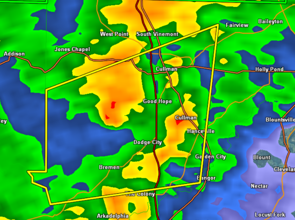
Severe Thunderstorm Warning Cullman County until 11:30 PM

This is the third warning for Cullman County tonight. A severe thunderstorm with a history of producing tree damage across Walker County has moved into Cullman County. This warning includes much of the county as well as the cities of Cullman, Hanceville, and Good Hope.
Use caution on local roadways as these storms will be impacting U.S. 31 and 278, as well as Interstate 65. Gusty winds, frequent lightning, and very heavy rainfall can be expected with these storms.
THE NATIONAL WEATHER SERVICE IN HUNTSVILLE HAS ISSUED A
* SEVERE THUNDERSTORM WARNING FOR…
WESTERN CULLMAN COUNTY IN NORTH CENTRAL ALABAMA…
* UNTIL 1130 PM CST
* AT 1051 PM CST…DOPPLER RADAR INDICATED A SEVERE THUNDERSTORM
CAPABLE OF PRODUCING DAMAGING WINDS IN EXCESS OF 60 MPH. THIS
STORM WAS LOCATED 7 MILES SOUTHWEST OF GOOD HOPE…AND MOVING EAST
AT 35 MPH.
* LOCATIONS IMPACTED INCLUDE…
CULLMAN…HANCEVILLE AND GOOD HOPE.
PRECAUTIONARY/PREPAREDNESS ACTIONS…
SEVERE THUNDERSTORMS PRODUCE DAMAGING WINDS IN EXCESS OF 60 MPH…
DESTRUCTIVE HAIL…DEADLY LIGHTNING AND VERY HEAVY RAIN. FOR YOUR
PROTECTION…MOVE TO AN INTERIOR ROOM ON THE LOWEST FLOOR OF YOUR
HOME OR BUSINESS. HEAVY RAINS FLOOD ROADS QUICKLY SO DO NOT DRIVE
INTO AREAS WHERE WATER COVERS THE ROAD.
Category: Alabama's Weather, Severe Weather
About the Author (Author Profile)
Subscribe
If you enjoyed this article, subscribe to receive more just like it.


