

Still Watching the Radar
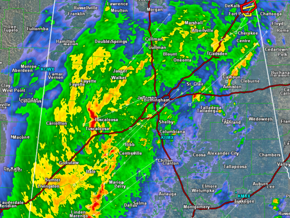
Heavy rain, frequent lightning, and gusty winds continue to impact area across Central Alabama this morning. We are watching a few areas carefully as there are still strong storms ongoing. One area we are keeping a close eye on is a line of storms across Tuscaloosa County. It is moving off to the northeast and will be heading into the Birmingham Metro over the next hour.
At this time, all storms remain below severe limits, but there is still a threat for severe weather the next few hours. Much of Central Alabama remains under a tornado watch until 3 AM. Until the front passes through, we are going to have to keep a close eye on these storms.
We will also be keeping watch on rainfall rates. Some reports of water standing on local roadways. If conditions do not improve, we could see some flood warnings needed later this morning. The storms will last a few more hours until a frontal boundary sweeps this activity out of the area.
…SIGNIFICANT WEATHER ADVISORY FOR TUSCALOOSA COUNTY UNTIL 115 AM
CST…
AT 1242 AM CST…THE NATIONAL WEATHER SERVICE WAS TRACKING STRONG
THUNDERSTORMS ALONG A LINE EXTENDING FROM SAMANTHA TO HOLT TO
MOUNDVILLE…AND MOVING EAST AT 55 MPH.
WIND GUSTS UP TO 50 MPH ARE EXPECTED WITH THESE STORMS.
LOCATIONS IN OR NEAR THE PATH OF THESE STORMS INCLUDE…
DEERLICK CREEK CAMPGROUNDS…
LAKE WILDWOOD…
BANKHEAD LOCK AND DAM…
BROOKWOOD…
COALING…
Category: Alabama's Weather, Severe Weather
About the Author (Author Profile)
Macon, Georgia Television Chief Meteorologist, Birmingham native, and long time Contributor on AlabamaWX. Stormchaser. I did not choose Weather, it chose Me. College Football Fanatic. @Ryan_StinnetSubscribe
If you enjoyed this article, subscribe to receive more just like it.


