

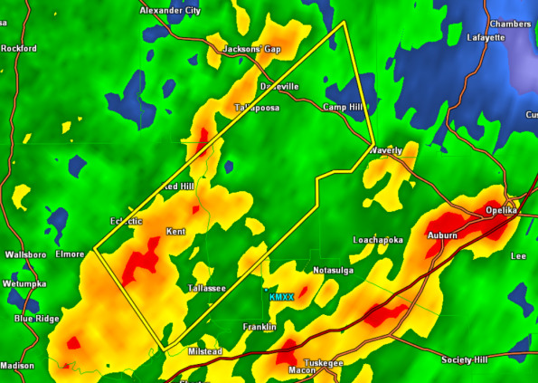
Severe Thunderstorm Warning Elmore/Tallapoosa until 3:30 AM

A severe storm capable of producing damaging winds is impacting the areas in the warning. This warning includes areas in and around Dadeville, Camp Hill, and Tallassee.
These storms will be impacting portions of U.S. 280 as well as state highway 49 & 229. This storm will continue to race off towards the northeast. The NWS detected winds of 50 kts just above the surface and those winds could make it down to the surface and produce damage in their wake.
THE NATIONAL WEATHER SERVICE IN BIRMINGHAM HAS ISSUED A
* SEVERE THUNDERSTORM WARNING FOR…
SOUTHEASTERN ELMORE COUNTY IN EAST CENTRAL ALABAMA…
SOUTHERN TALLAPOOSA COUNTY IN EAST CENTRAL ALABAMA…
* UNTIL 330 AM CST
* AT 250 AM CST…THE NATIONAL WEATHER SERVICE INDICATED A SEVERE
THUNDERSTORM CAPABLE OF PRODUCING DAMAGING WINDS IN EXCESS OF 60
MPH. THIS STORM WAS LOCATED 5 MILES SOUTHWEST OF KENT…OR 6 MILES
WEST OF TALLASSEE…AND MOVING NORTHEAST AT 60 MPH.
* LOCATIONS IMPACTED INCLUDE…
DADEVILLE…CAMP HILL…MARTIN DAM…STILL WATERS RESORT…
REELTOWN…BLUE CREEK MARINA…MAXWELL GUNTER RECREATION AREA AND
LAKE MARTIN SUSANNAH CROSSING.
WINDS OF 60 TO 70 MPH WILL BREAK LARGE TREE LIMBS AND CAUSE SOME
DAMAGE…ESPECIALLY TO SMALLER STRUCTURES.
PRECAUTIONARY/PREPAREDNESS ACTIONS…
FOR YOUR PROTECTION…MOVE TO AN INTERIOR ROOM ON THE LOWEST FLOOR OF
YOUR HOME OR BUSINESS.
Category: Alabama's Weather, Severe Weather
About the Author (Author Profile)
Subscribe
If you enjoyed this article, subscribe to receive more just like it.


