Cold Not Far Away
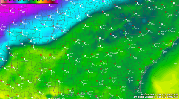
We are dealing with a very sharp cold front not very far to our north. Look at these temperature contrasts at 9 a.m.:
61F in Tupelo, 37F in Memphis (90 miles)
64F in Nashville, 34F in Hopkinsville KY (55 miles)
66F in Longview TX, 37 in Mouth Pleasant (45 miles)
Here in Nashville, I went down to breakfast at 945 with a temperature of 65F, and when I stepped outside at 10:30, it was 45F!
We continue to watch a major winter storm to the north and northwest of Alabama on this first Sunday in March. If you go anywhere from New Mexico to New York City, you will be under a winter weather advisory, watch or warning. Winter storm warnings are as close as northern Mississippi and western Tennessee. The entire states of Kentucky and West Virginia are under winter storm warnings.
The National Weather Service in Huntsville has posted a winter weather advisory for late tonight and early Monday for Colbert, Lauderdale, Franklin, Lawrence and Limestone Counties. A wintry mix will spread into Northwest Alabama around 4-5 a.m. and will spread across the Tennessee Valley Counties into places like Huntsville and Scottsboro through sunrise. More patches of a light wintry mix of freezing rain and sleet will spread across the area along and north of US-278 through the morning hours, diminishing by noon.
This means that folks in Marion, Winston and Cullman Counties, over into Marshall, Etowah and Cherokee Counties may deal with some light freezing rain or sleet early Monday morning as temperatures fall quickly to freezing behind a cold front and precipitation continues to stream across the area.
South of US-278, temperatures will remain above freezing until Monday night and the precipitation will be long gone by then.
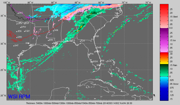
Here is a peek at the RPM model for 8:30 a.m. tomorrow morning showing some light wintry mix across North Alabama in areas along and north of US-278.
IN THE HERE AND NOW: Clouds have held tough this morning in areas generally along and north of I-59. There was even some early fog. Surprisingly, early temperatures were not affected significantly by the clouds, with generally everyone in the lower 60s, a testament to the relatively warm airmass in place over Alabama. A few places in the heavier cloudiness are in the upper 50s. Everyone should get into the 70s by this afternoon with a mix of clouds and sun as those clouds erode, but other clouds move into later today. There could be a few sprinkles before the clouds erode in those areas north of I-59.
PRECIP MOVES OUT TOMORROW: The rain will be mainly southeast of I-59 by 7 a.m. tomorrow and will race eastward out of the state by 10 a.m. or so. Most everyone should see a decent soaking, overnight tonight and early Monday with about one half inch of rain on average. Monday will be a blustery day with clearing skies, but a strong northwest wind will make it feel sort of miserable.
MISERABLE MONDAY MERCURY: The ol’ thermometer will fall quickly into the 30s this evening over Northwest Alabama. The front will reach Hamilton a little after sunset, Cullman by 9, Tuscaloosa by 11, Birmingham/Gadsden by midnight and Anniston by 2 a.m. It will get into Middle Alabama around Clanton by 8 a.m. or so. Temperatures behind the front will fall into the middle 30s in the I-59 corridor before rebounding a tiny bit into the upper 30s as sun peeks back out for awhile. Lows Monday night will fall below freezing across all of Central Alabama, with upper 20s across the northern half of the area.
Category: Alabama's Weather, Headlines, Winter Weather


