

Rain and Cold Air Moving In
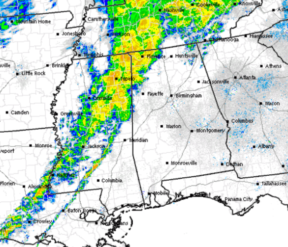
The main areas of showers with a few embeded thunderstorms are now making their way into western portions of the state. Moderate to heavy rain is falling from Lauderdale County in the northwestern corner of the state, south to Pickens County currently. The best radar returns in Central Alabama are coming from Lamar and Marion Counties. This activity will continue to head east over the next few hours, and most of us can expect to see the rain this morning.
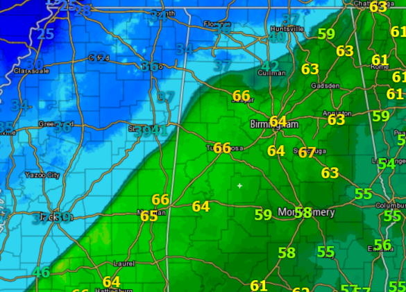
Now to those ever important temperatures. Cold air is making its way into Alabama, and we are seeing quite the temperature gradient across the state. The cold air has made it to Haleyville where it is in the 30s and Cullman where the temp is in the low 40s, while just south of the front, Jasper remains in the 60s. In the Tennessee Valley, 30s are widespread. Over the next few hours the front will continue to drop towards the south and we will be seeing all temps drop like a rock across the area.
Still receiving reports of all rain currently, but later in the morning hours, we will likely have some wintry mix of precip. as freezing rain, sleet, and snow will be possible. A freezing rain advisory will be in effect later this morning for some of our northwestern counties, while counties in the Tennessee Valley are under a winter weather advisory.
Category: Alabama's Weather, Winter Weather
About the Author (Author Profile)
Macon, Georgia Television Chief Meteorologist, Birmingham native, and long time Contributor on AlabamaWX. Stormchaser. I did not choose Weather, it chose Me. College Football Fanatic. @Ryan_StinnetSubscribe
If you enjoyed this article, subscribe to receive more just like it.


