

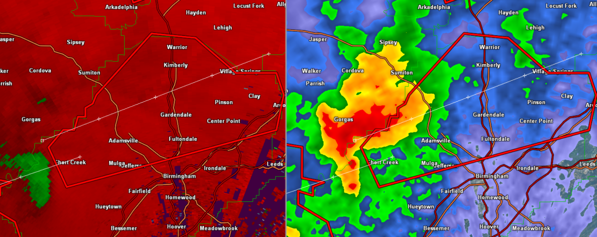
Tornado Warning Jefferson County until 10:30 PM

Strong rotation will be moving just north of Downtown Birmingham. This storms will not be affecting the Over the Mountain communities and will be affecting the western, northern and eastern suburbs of the city. Travel is not recommended north of downtown along Interstate 65 or out Interstate 59 of 22.
Sylvan Springs, Gardendale, Fultondale, Trussvill, Center Point, Pinson, North Birmingham are all in the path of this storm.
Click image to enlarge.
THE NATIONAL WEATHER SERVICE IN BIRMINGHAM HAS ISSUED A
* TORNADO WARNING FOR…
NORTHERN JEFFERSON COUNTY IN ALABAMA…
* UNTIL 1030 PM CDT
* AT 922 PM CDT…THE NATIONAL WEATHER SERVICE INDICATED A SEVERE
THUNDERSTORM CAPABLE OF PRODUCING A TORNADO. THIS DANGEROUS STORM
WAS LOCATED NEAR SYLVAN SPRINGS…OR 10 MILES NORTHWEST OF
HUEYTOWN…AND MOVING NORTHEAST AT 25 MPH.
* LOCATIONS IMPACTED INCLUDE…
FULTONDALE…GARDENDALE…TRUSSVILLE…WEST JEFFERSON…MAYTOWN…
MULGA…ADAMSVILLE…GRAYSVILLE…FORESTDALE AND CARDIFF.
THIS INCLUDES…
INTERSTATE 65 EXIT NUMBERS 266 THROUGH 282…
US 78 EXIT NUMBERS 81 THROUGH 91…
INTERSTATE 59 EXIT NUMBERS 141 THROUGH 143…
PRECAUTIONARY/PREPAREDNESS ACTIONS…
TAKE COVER NOW. FOR YOUR PROTECTION MOVE TO AN INTERIOR ROOM ON THE
LOWEST FLOOR OF A STURDY BUILDING.
Category: Alabama's Weather, Severe Weather
About the Author (Author Profile)
Subscribe
If you enjoyed this article, subscribe to receive more just like it.


