Tornado Warning Lee/Macon Counties until 4 AM

A confirmed tornado is ongoing with this storm as this storm has a TDS with it. It is affecting portions of Macon County and will be lifting north into Lee County. This storm will move very close to Auburn University, but should stay just to the east of the campus and town. Opelika is in the path of this storm. Take shelter now if you are in this warning.
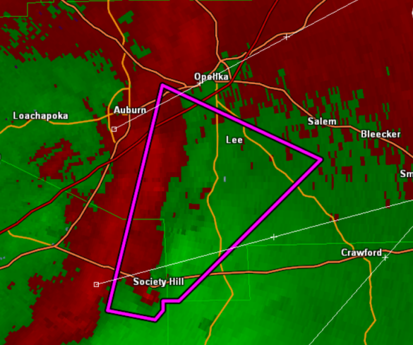
THE NATIONAL WEATHER SERVICE IN BIRMINGHAM HAS ISSUED A
* TORNADO WARNING FOR…
CENTRAL LEE COUNTY IN EAST CENTRAL ALABAMA…
EAST CENTRAL MACON COUNTY IN SOUTHEAST ALABAMA…
* UNTIL 400 AM CDT
* AT 327 AM CDT…THE NATIONAL WEATHER SERVICE WAS TRACKING A
CONFIRMED TORNADO NEAR SOCIETY HILL…OR 12 MILES SOUTH OF AUBURN.
DOPPLER RADAR SHOWED THIS TORNADO MOVING NORTH AT 50 MPH.
* LOCATIONS IMPACTED INCLUDE…
BEAUREGARD AND ROBERT G. PITTS AIRPORT.
THIS INCLUDES…
INTERSTATE 85 EXIT NUMBERS 57 THROUGH 58…
PRECAUTIONARY/PREPAREDNESS ACTIONS…
TAKE COVER NOW. FOR YOUR PROTECTION MOVE TO AN INTERIOR ROOM ON THE
LOWEST FLOOR OF A STURDY BUILDING.
TO REPORT SEVERE WEATHER…
CALL 1-800-856-0758 OR TWEET YOUR REPORT USING HASHTAG ALWX
Category: Alabama's Weather, Severe Weather
About the Author (Author Profile)
Subscribe
If you enjoyed this article, subscribe to receive more just like it.


