

Tornado Watch Coming to our West
Here is an update on the Alabama Weather Situation at 12:30.
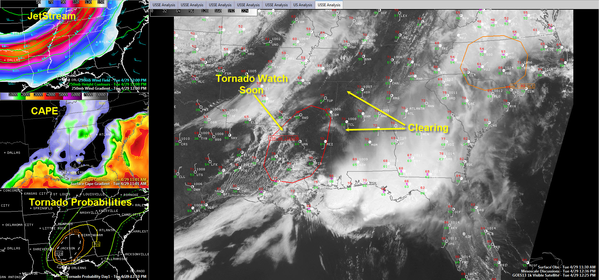
The third and final round of our multi-day severe weather event is kicking off right now as thunderstorms fire over northeastern Louisiana.
The airmass over Alabama and Mississippi is a little less moist than the one we started with yesteday, but dewpoints have been rising all morning. At Jackson, the dewpoint has risen from 55F to 64F over the past few hours. Alexandria LA has jumped from 61F to 70F. Tusclaoosa’s dewpoint is at 67F, Birmingham’s at 63F. Those values will rise a couple of more degrees.
A troubling sign is the return of blue skies across much of the area. They are appearing on Skycams like Birmingham, Tuscaloosa, Jasper, Hamilton and Fayette. Temperatures will heat up quickly as we head into the afternoon. The heat and moisture will be the fuel.
Another troubling sign is that a surface low has formed over western Louisiana. This low will do things: it will accelerate the moisture influx from the south, and it will provide backed, or southeasterly surface winds, which will greatly increase low level shear. This of course enhances the probability that tornadoes will form.
Oh, something else that worries me. The mid level lapse rates over Alabama are MUCH steeper than yesterday. The poor lapse rates were a limiting factor in the convection running away yesterday. So the storms today may have more vigorous updrafts. That’s a bad thing.
The SPC has just alerted us that they will be coordinating a tornado watch shortly, likely before 1 p.m. for parts of Louisiana and Mississippi. In this area, a deep cumulus field has formed in the moist and unstable airmass. Storms were starting to fire in Northeast Louisiana to the east of Monroe.
These storms will explode as they tap the upper diffluence provided by a powerful jetstream just to the west. Winds at 33,000 feet are running 150 mph from Northeast Texas into Arkansas. This jetmax will propagate eastward into Arkansas this afternoon and evening, enhancing the list and leading to widespread intense thunderstorms.
The Moderate Risk was shifted just a tad to the south on the latest update but Birmingham is still in it.
The SPC has a large area of 15% probabilities for tornadoes within 25 miles of a point from Northeast Louisiana to Birmingham, including much of the southwestern third of Alabama and a large part of Mississippi. This area also contains a large hatched area delineating where the experts think strong (EF2) tornadoes are likely. Some of these tornadoes today will likely be long tracked as well, given their supercellular lineage.
So, stay weather aware this afternoon and tonight. Have your plan. Have your safe place. And have your way of getting warnings. And we will get through this situation just fine.
Category: Alabama's Weather, Severe Weather
About the Author (Author Profile)
Bill Murray is the President of The Weather Factory. He is the site's official weather historian and a weekend forecaster. He also anchors the site's severe weather coverage. Bill Murray is the proud holder of National Weather Association Digital Seal #0001 @wxhistorianSubscribe
If you enjoyed this article, subscribe to receive more just like it.


