Tropical Storm Cristobal
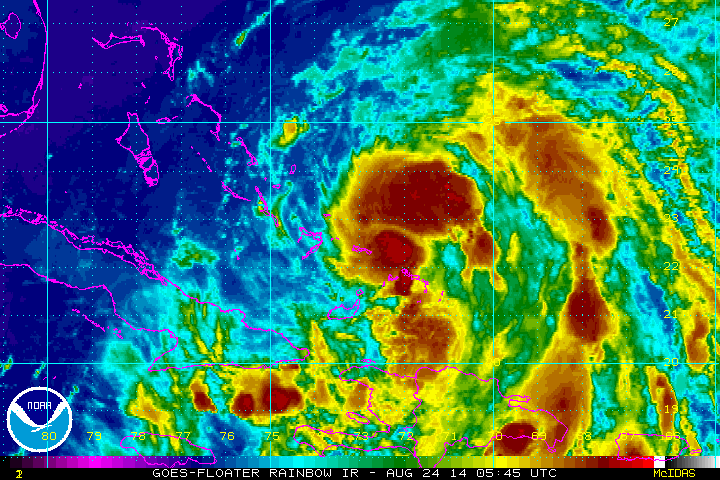
Earlier this morning, tropical depression four was named Tropical Storm Cristobal. Over the next few days, Cristobal will continue to intensify and is expected to reach hurricane strength off the Southeast Coast. Looking at the satellite imagery, Cristobal is a healthy looking system, with decent inflow and outflow. Being in favorable environmental conditions, there should be no reason why Cristobal will not continue to get better organized through the afternoon and first part of the week.
Latest specifics on the storm.
…CRISTOBAL RE-FORMS A LITTLE TO THE NORTHEAST…
…STILL MOVING NORTHWESTWARD NEAR THE SOUTHEASTERN BAHAMAS…
SUMMARY OF 800 AM EDT…1200 UTC…INFORMATION
———————————————-
LOCATION…23.0N 73.0W
ABOUT 40 MI…60 KM N OF MAYAGUANA ISLAND
ABOUT 135 MI…215 KM ESE OF LONG ISLAND
MAXIMUM SUSTAINED WINDS…45 MPH…75 KM/H
PRESENT MOVEMENT…NW OR 325 DEGREES AT 9 MPH…15 KM/H
MINIMUM CENTRAL PRESSURE…1001 MB…29.56 INCHES
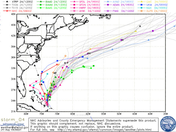
Now the most important question, where is Cristobal heading? Most of the computer models are pulling the system away from the U.S. mainland. No worries for the Gulf of Mexico, and it should stay far enough away from the East Coast to cause no major issues. It look as though the island of Bermuda will certainly need to be on guard as the models show Cristobal moving very close to the island.
Category: Alabama's Weather, Tropical
About the Author (Author Profile)
Macon, Georgia Television Chief Meteorologist, Birmingham native, and long time Contributor on AlabamaWX. Stormchaser. I did not choose Weather, it chose Me. College Football Fanatic. @Ryan_StinnetSubscribe
If you enjoyed this article, subscribe to receive more just like it.


