

Bitterly Cold Air Arrives Wednesday
An all new edition of the ABC 33/40 Weather Xtreme video is available in the player on the right sidebar of the blog. You can subscribe to the Weather Xtreme video on iTunes by clicking here.
COLD TODAY; MUCH COLDER WEDNESDAY: Our attention this week turns from strong thunderstorms to Arctic air. Today will be considerably colder across the great state of Alabama; we are projecting a high only in the low 40s despite a good supply of sunshine.
We get a one day warm-up tomorrow; a good chance we reach the mid 50s with a sunny sky; that is right at seasonal averages for early January. But, the warmer weather sure won’t last long.
ICY WIND WEDNESDAY: North winds will average 12-25 mph Wednesday, with gusts to 30 mph as very cold, Arctic air blows into our state. The high will be only in the upper 30s, and the wind chill index will be below zero most of the day, despite a partly to mostly sunny sky. The wind chill index will drop below zero at times over North Alabama Wednesday night.
FRIGID THURSDAY: Places like Birmingham, Anniston, Gadsden, and Tuscaloosa can expect a low between 10 and 15 degrees at daybreak Thursday, with single digit lows to the north as a very strong anticyclone settles into the Deep South. We expect to stay below freezing all day Thursday, despite sunshine in full supply.
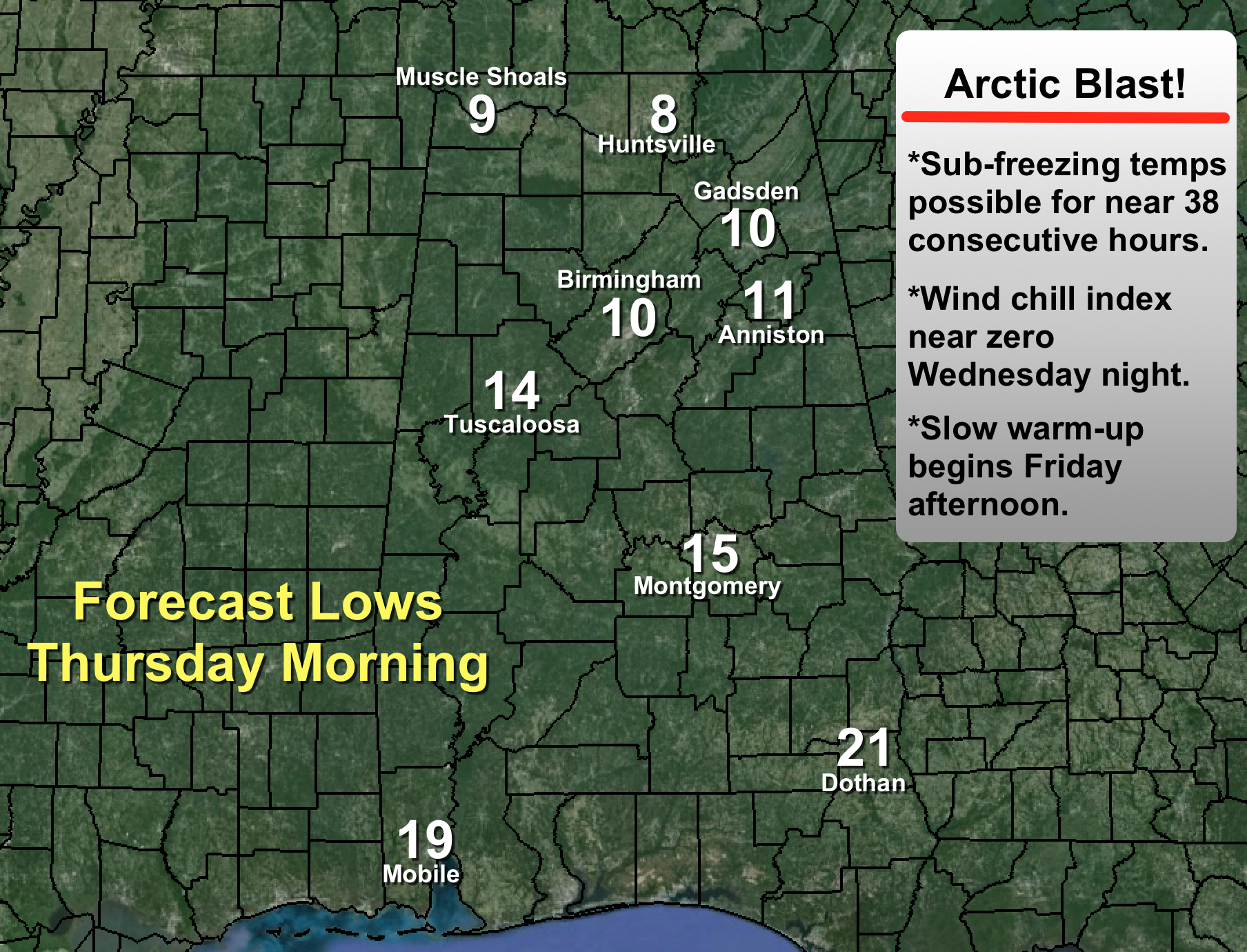
Friday morning will also be very cold with a low in the teens. Much of North Central Alabama will go below freezing around 7 p.m. Wednesday, and stay below freezing until around 9 a.m. Friday… a total of 38 consecutive hours with sub-freezing temperatures. Today is a good time to check on elderly people or others who might not have an adequate source of heat. Take care of exposed pipes, and bring in the pets. You know the routine…
We should reach the mid 40s Friday as a slow warming trend begins. And, we should point out the cold air is dry, and there is no worry about snow or ice issues in Alabama. We will be dry for the next five days.
THE ALABAMA WEEKEND: Saturday for now looks dry with a partly sunny sky and a high in the upper 40s. Then, short wave energy will bring the chance of a few showers Sunday; doesn’t look like a big rain event at the moment. A decent chance we reach the low 50s Sunday despite the clouds and showers.
LONG RANGE: Seeing some evidence of the Arctic Oscillation (AO) and the North Atlantic Oscillation (NAO) going negative at mid-month; that could suggest a colder pattern for the eastern and southern U.S. We will see…. check out the Weather Xtreme video for the maps, graphics, and more details.
WEATHER BRAINS: Don’t forget you can listen to our weekly 90 minute netcast anytime on the web, or on iTunes. This is the show all about weather featuring many familiar voices, including our meteorologists here at ABC 33/40. We will produce this week’s show at 8:30 CT tonight… you can watch it on “James Spann 24/7” on cable systems around the state, or on the web here.
CONNECT: You can find me on all of the major social networks…
Facebook
Twitter
Google Plus
Instagram
Look for the next Weather Xtreme video here by 4:00 or so this afternoon. Enjoy the day!
Category: Alabama's Weather
About the Author (Author Profile)
James Spann is one of the most recognized and trusted television meteorologists in the industry. He holds the AMS CCM designation and television seals from the AMS and NWA. He is a past winner of the Broadcast Meteorologist of the Year from both professional organizations.Subscribe
If you enjoyed this article, subscribe to receive more just like it.


