

Late Morning Update
Everything is unfolding sort of as planned in our morning forecast with widespread light to occasionally moderate rain spreading across North and Central Alabama. The only real difference is that the rain is arriving a bit before I thought it would this morning.
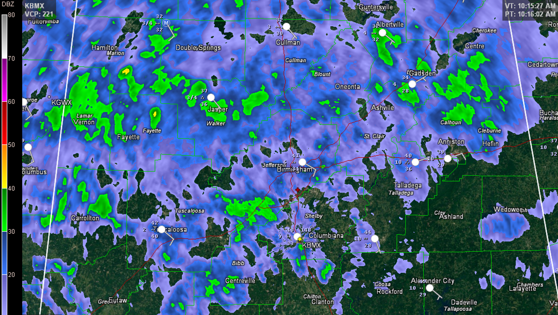
The good news is that temperatures are behaving with readings in the I-20 corridor ranging from 39F at Birmingham and Anniston to 40F at the Speedway and Tuscaloosa, so everything is falling as rain and no problems are being reported.
Further north, temperatures are at freezing along the US-278 corridor with Unknown Precipitation being reported and 32F at Haleyville, Vinemont and Albertville.
Winter Storm Warning for Colbert and Lauderdale Counties till 6:00 PM CST with up to 1/4 inch of ice accumulation expected. Winter Weather Advisory for De Kalb, Franklin, Jackson, Lawrence, Limestone, Madison, Marshall and Morgan Counties till 6:00 PM CST with up to one tenth of an inch of ice accumulation expected.
Some ice is forming on exposed objects around Pinson in northeastern Jefferson County and at Springville in St. Clair County. But don’t expect travel problems there.
Some recent reports in the past hour…
NORTH ALABAMA
…Cairo in Limestone County…tables covered with icy glaze
…Near Town Creek in NW Lawrence County County…Highway 101 icing up
…Car windshields frozen on Monte Sano near Huntsville…patchy ice on roads, but still passable
…Ice accumulating on bushes, tree tops and powerlines near Georgia Mountain community near Union Grove in Marshall County.
…UAH/NWS Huntsville Office reporting 34F with light rain as of 9:36
…Ice accumulating on mailboxes and vehicles in Boaz
MIDDLE TENNESSEE
…The NWS Nashville has converted their southern counties from a winter storm warning to an ice storm warning, including the communities of Lawrenceburg, Columbia, Murfreesboro and Tullahoma. They are calling for 1/4 to ONE INCH of ice in the warning area.
…Nashville is still under winter storm warning for 1/4 inch of freezing rain and sleet with 1-4 inches of snow. 30F with freezing rain there this hour.
…There was a report of a major multi-car accident on I-65 near Columbia this morning with overturned vehicles.
…0.10″ of ice in Old Hickory.
…Smyrna, icy glaze on everything.
…Slightly more than 1/4″ of ice around Franklin just south of Nashville.
…0.38″ at Gallatin.
…7 miles north of Gallatin: 0.30 inches of ice is on everything around the county, even the roads, travel is just about impossible across the whole county.
…0.35″ near Murfreesboro with limbs starting to snap off trees.
…Portland TN has 4 inches of snow.
WESTERN TENNESSEE
…3 inches of sleet at Union City.
…Accumulated sleet in Midtown Memphis.
…1 inch of sleet at Jackson
KENTUCKY
…Big snowstorm at Hopkinsville in western Kentucky. 6″ at last report.
ALABAMA POWER IS READY, ARE YOU? Our friends at Alabama Power are monitoring the forecast closely, ready to deploy people and assets to quickly address any outages that might occur. Read a special message from Ike Piggot about their commitment to their customers.
Category: Alabama's Weather, Winter Weather
About the Author (Author Profile)
Bill Murray is the President of The Weather Factory. He is the site's official weather historian and a weekend forecaster. He also anchors the site's severe weather coverage. Bill Murray is the proud holder of National Weather Association Digital Seal #0001 @wxhistorianSubscribe
If you enjoyed this article, subscribe to receive more just like it.


