Winter Storm Warning
**No afternoon Weather Xtreme video today; having to spend most of my time dealing with TV!**
WINTER STORM WARNING: NWS offices in Birmingham and Huntsville have issued winter storm warnings for much of North and down into Central Alabama. Winter storm warnings are up for Birmingham, Anniston, Gadsden, and Tuscaloosa.
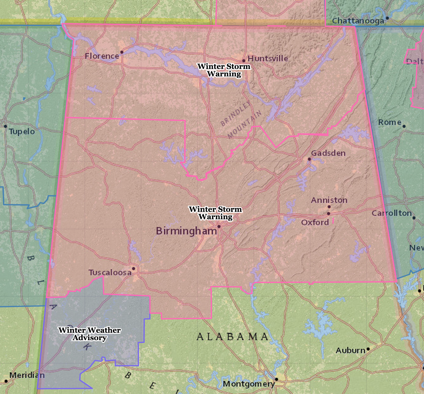
We should note a winter weather advisory has been issued down into the Greensboro/Demopolis area of West Alabama, where some light snow is possible.
This is our public forecast…
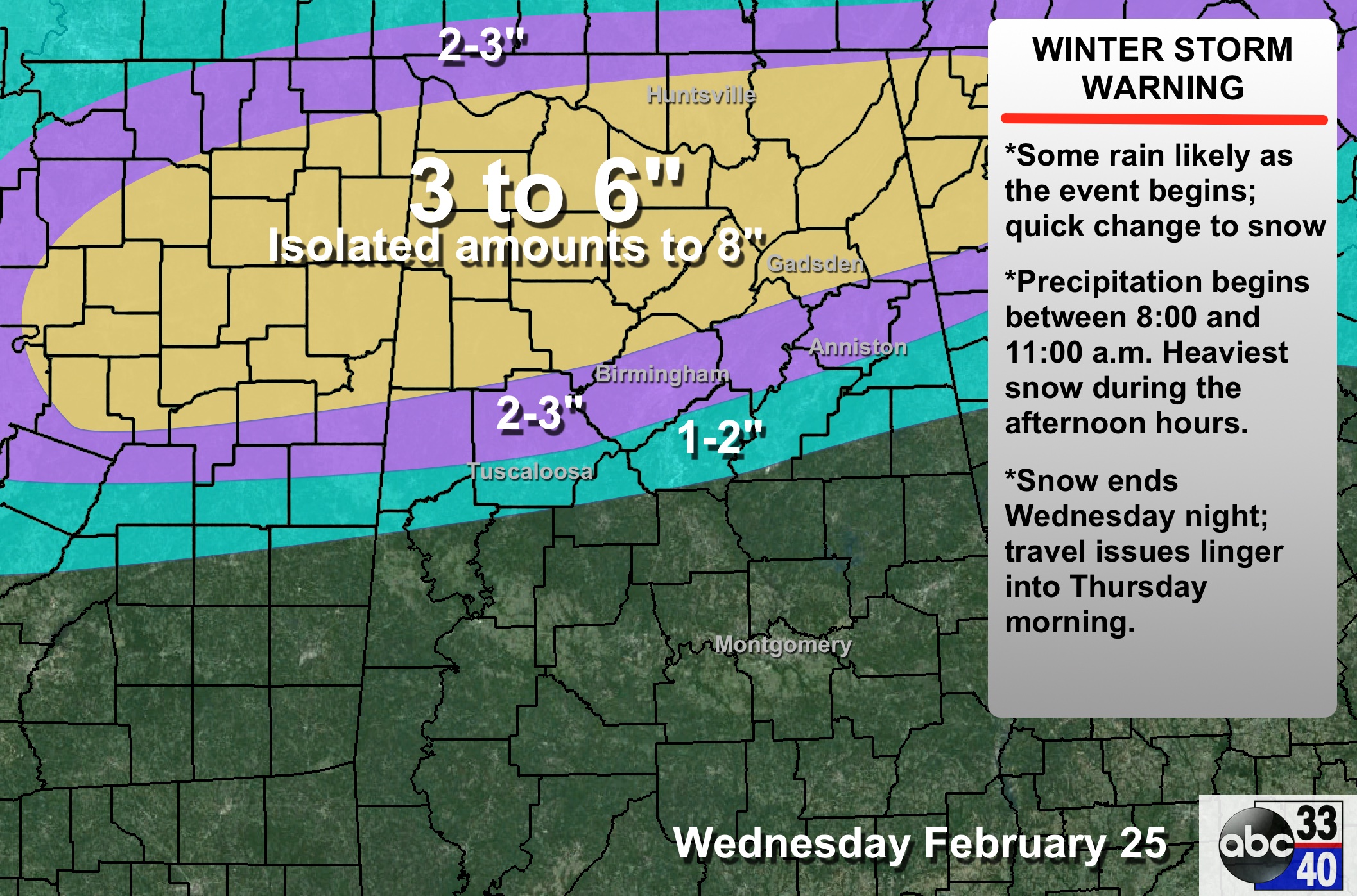
TIMING: It begins in West Alabama as early as 8:30… then the precipitation moves east. It should reach Birmingham around 10:30, and Anniston/Gadsden around 11:30. Understand these are approximate times. The heaviest snow comes from 12:00 noon until 6:00 p.m., and then it winds down tomorrow night.
ACCUMULATION POTENTIAL/PLACEMENT: Within the heaviest snow band, which should be somewhere between Birmingham and Huntsville, amounts of 3-6 inches are likely, with isolated amounts to 8 inches. We might even hear of some reports of thundersnow in that zone. We project 2-3″ for Birmingham, and 1-2″ for Tuscaloosa. Please understand the snow will not follow the clean lines we are showing on the map above… they are just a broad guideline. Anniston and Gadsden are on those lines as you can see; amounts could go either way there.
IMPACT: Travel conditions will deteriorate quickly tomorrow afternoon as the heavy snow falls. Hazardous travel is likely through tomorrow night and Thursday morning; temperatures will ease above freezing by mid-morning Thursday, and after that roads will improve.
BIGGEST CHALLENGE: The exact placement of the rain-snow line. For now we project it along a line from Eutaw to Brent to Calera to Ashland to Wedowee. This might have to be adjusted north or south a bit later tonight and tomorrow morning as the event unfolds. South Alabama will simply have a cold rain.
REMEMBER: For the snow lovers, some of you will be delighted with the amount of snow you see tomorrow, others severely disappointed. See the 10 things you need to know about winter weather forecasting. And, of course, the forecast can and will change.
THURSDAY/FRIDAY: These two days will be dry with highs between 40 and 45; the sky will feature a mix of sun and clouds.
OUR WEEKEND: We expect a high in the low to mid 50s Saturday and Sunday; a touch of light rain is possible Sunday, but much of the weekend will be dry.
Showers and storms return early next week; too early to be specific.
ALABAMA POWER IS READY, ARE YOU? Our friends at Alabama Power are monitoring the forecast closely, ready to deploy people and assets to quickly address any outages that might occur. Read a special message from Ike Pigott about their commitment to their customers.
WEATHER BRAINS: Don’t forget you can listen to our weekly 90 minute netcast anytime on the web, or on iTunes. This is the show all about weather featuring many familiar voices, including our meteorologists here at ABC 33/40.
CONNECT: You can find me on all of the major social networks…
Facebook
Twitter
Google Plus
Instagram
Stay tuned for updates through the night…
Category: Alabama's Weather
About the Author (Author Profile)
James Spann is one of the most recognized and trusted television meteorologists in the industry. He holds the AMS CCM designation and television seals from the AMS and NWA. He is a past winner of the Broadcast Meteorologist of the Year from both professional organizations.Subscribe
If you enjoyed this article, subscribe to receive more just like it.


