Big Snow For North Alabama
An all new edition of the ABC 33/40 Weather Xtreme video is available in the player on the right sidebar of the blog. You can subscribe to the Weather Xtreme video on iTunes by clicking here.
Let me say up front that I would like for you to read the 10 things people need to know about winter weather forecasts. I know most of you have, but on days like today we have many new readers that have not seen it. Also, please take a few minutes and watch the Weather Xtreme video… it has all of the maps, graphics, and details beyond this discussion.
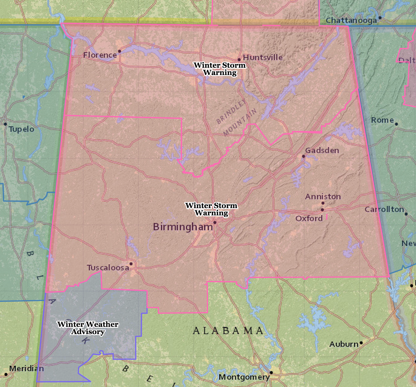
WINTER STORM WARNING: There have been no changes in the winter storm warning issued by NWS offices in Birmingham and Huntsville. The warning includes Birmingham, Tuscaloosa, Anniston, and Gadsden.
No changes in the forecast I put out last night around 9:00…
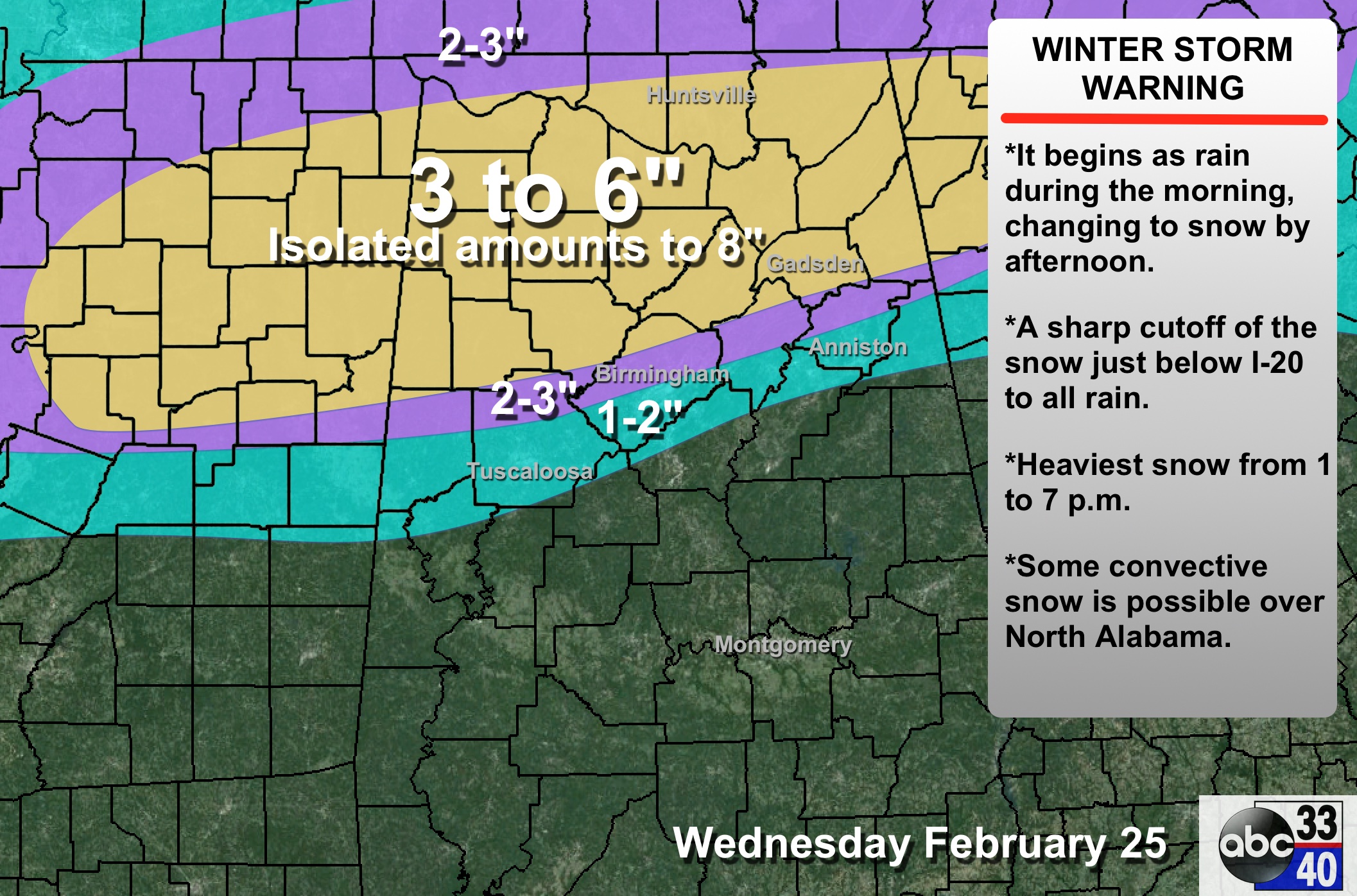
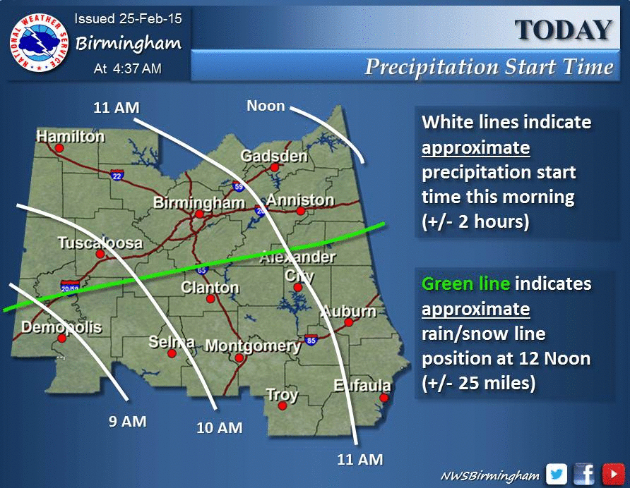
TIMING: Precipitation (generally in the form of rain) begins in the 9:00-12:00 noon time frame; it changes to snow quickly along and north of I-20; the heaviest snow over North Alabama will come from 1:00 until 7:00 p.m. The precipitation will end tonight between 9:00 p.m. and midnight for most.
For those in the “snow zone”, I would be off the roads by late morning. Here is a timing graphic from the NWS Birmingham…
ACCUMULATION POTENTIAL: The biggest snow should be near the U.S. 278 corridor (Hamilton to Cullman to Gadsden), with average amounts of 3-6 inches; isolated amounts to 8 inches are possible. Some convective snow (complete with thunder and lightning) is possible in this heavier snow zone this afternoon and early tonight.
PLACEMENT: As stated here for days, the hardest part of the forecast is the boundary between rain and snow. This will be near, or just south of I-20. And, of course, it won’t be along a neat, clean line like we draw on the maps. Why do we draw them, then? It just serves as a general guideline.
Albert Einstein, Barack Obama, George Bush, Country Boy Eddie, or anyone else in the world has no idea EXACTLY where that rain-snow line will be today.
To the south of that line, it will be a cold, rainy day.
IMPACT: Where the heavy snow band sets up over North Alabama today, there could be enough heavy, wet snow for a few scattered shower outages. Travel will be severely disrupted in the snow zone this afternoon, tonight, and tomorrow morning. Temperatures rise above freezing by mid-morning tomorrow, when conditions begin to improve.
UNDERSTAND: This forecast can, and probably will change later this morning before the event begins. If you don’t check for updates, you will be using old information that is not very helpful. And, with this and any winter weather event in Alabama, there will be some snow lovers that are delighted with the snow they see today, and others that are severely disappointed.
TOMORROW/FRIDAY: These two days will be dry but cool; we reach the mid 40s tomorrow, but the high Friday will be closer to 40 as a secondary push of cold air moves in.
THE ALABAMA WEEKEND: Saturday will be partly sunny with a high in the low 50s; some scattered light rain is possible Sunday as moisture returns; we reach the mid 50s Sunday afternoon.
NEXT WEEK: Showers are possible Monday through Wednesday; thunderstorms could be involved by Tuesday night and Wednesday as a surface low passes to the north. And, it will be much warmer; the 00Z GFS is printing a high of 71 for Birmingham on Tuesday. See the Weather Xtreme video for more long range details.
ALABAMA POWER IS READY, ARE YOU? Our friends at Alabama Power are monitoring the forecast closely, ready to deploy people and assets to quickly address any outages that might occur. Read a special message from Ike Pigott about their commitment to their customers.
WEATHER BRAINS: Don’t forget you can listen to our weekly 90 minute netcast anytime on the web, or on iTunes. This is the show all about weather featuring many familiar voices, including our meteorologists here at ABC 33/40.
CONNECT: You can find me on all of the major social networks…
Facebook
Twitter
Google Plus
Instagram
Stay tuned to the blog through the day for updates…
Category: Alabama's Weather
About the Author (Author Profile)
James Spann is one of the most recognized and trusted television meteorologists in the industry. He holds the AMS CCM designation and television seals from the AMS and NWA. He is a past winner of the Broadcast Meteorologist of the Year from both professional organizations.Subscribe
If you enjoyed this article, subscribe to receive more just like it.


