

Warming Trend Through Wednesday, Then Colder
An all new edition of the ABC 33/40 Weather Xtreme video is available in the player on the right sidebar of the blog. You can subscribe to the Weather Xtreme video on iTunes by clicking here.
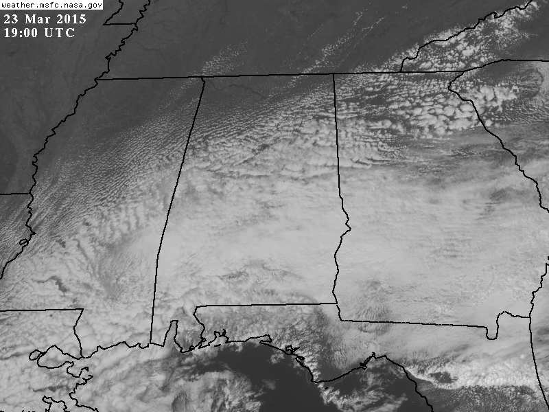
SLOW CLEARING: While the Tennessee Valley has enjoyed a mostly sunny sky much of the day, clouds have lingered along and south of I-20…
Temperatures are in the low 70s over far North Alabama where the sun is shining; elsewhere we are seeing mostly 60s.
TOMORROW AND WEDNESDAY: These two days look dry and mild with a mix of sun and clouds, and highs generally in the 70s. The NAM model is suggesting we could be close to 80 degrees in spots Wednesday afternoon.
To the west of Alabama, strong to severe storms are possible on these days across parts of Oklahoma, Arkansas, and Missouri, but those won’t bother us.
LATE WEEK COLD FRONT: Clouds will increase Thursday, and we will mention a chance of showers, and possibly a thunderstorm Thursday afternoon and Thursday night. No severe weather is expected, and rain amounts should be under 1/2 inch. Much colder air will return to the state Friday; we won’t make it past the mid 50s with a chilly north wind. A lingering shower is possible Friday morning in spots, but most of the day should be rain-free.
RAW, COLD SATURDAY: A cold, deep upper trough will set up a mostly cloudy and rather raw day Saturday. Some light rain, and maybe even a snow flake or two will be possible as the trough passes; temperatures will struggle to get out of the 40s with a very cool north breeze. It sure won’t feel like a spring day.
There is potential for a late season freeze early Sunday morning with a clear sky and light wind; we project a low in the 28-33 degree range for North/Central Alabama, so growers beware. Then, we expect a good supply of sunshine during the day Sunday with a high back in the 60s as a warming trend begins.
NEXT WEEK: Monday and Tuesday look mostly dry with highs in the 70s; some risk of showers and storms will return by mid-week, but model consistency has not been good with that next feature.
GULF COAST WEATHER: Mostly dry weather through Wednesday on the coast from Panama City to Gulf Shores; a few scattered showers are possible Thursday night and Friday. Highs will be in the low 70s tomorrow through Thursday, but back in the 60s Friday. Then, a cool weekend is ahead… mostly sunny Saturday and Sunday, but with a high in the 50s Saturday and 60s Sunday. Early morning temperatures will reach the 40s on the coast this weekend. The sea water temperature this afternoon at the Dauphin Island Sea Lab is up to 71 degrees.
WEATHER BRAINS: Don’t forget you can listen to our weekly 90 minute netcast anytime on the web, or on iTunes. This is the show all about weather featuring many familiar voices, including our meteorologists here at ABC 33/40. We will produce this week’s show tonight at 8:30 CT… you can watch it on “James Spann 24/7” on cable systems around the state, or on the web here.
CONNECT: You can find me on all of the major social networks…
Facebook
Twitter
Google Plus
Instagram
I enjoyed seeing 2nd graders today at Meadow View Elementary in Alabaster and West Elementary in Vestavia Hills… be looking for them on the Pepsi KIDCAM today at 5:00 and 6:00 on ABC 33/40 News! The next Weather Xtreme video will be posted here by 7:00 a.m. tomorrow…
Category: Alabama's Weather
About the Author (Author Profile)
James Spann is one of the most recognized and trusted television meteorologists in the industry. He holds the AMS CCM designation and television seals from the AMS and NWA. He is a past winner of the Broadcast Meteorologist of the Year from both professional organizations.Subscribe
If you enjoyed this article, subscribe to receive more just like it.


