Tropical Storm Fay Forms
An all new edition of the ABC 33/40 Weather Xtreme video is available in the player below, and on iTunes…
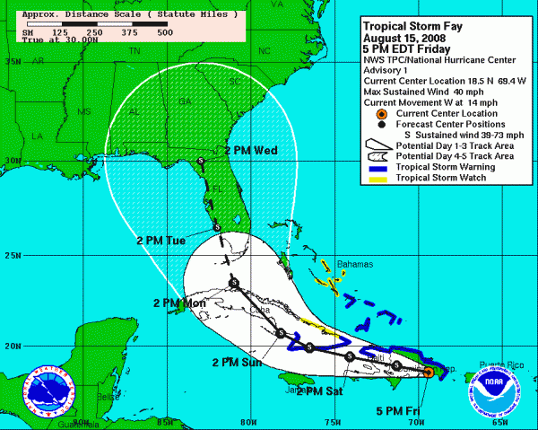
**NHC upgrades the tropical wave near Hispanolia to Tropical Storm Fay at 3:30** Here is the NHC track, just out:
CLOSE TO HOME: Sure looks like we need to mention a chance of scattered showers tonight and tomorrow as an upper impulse moves across the Deep South. You can see showers associated with this disturbance on radar now over Mississippi; those will move into Alabama this evening, dissipating late tonight. Then, tomorrow with the daytime heating process a few scattered showers and storms will be possible. Looks like the best coverage will be over the southern half of the state; highs will be mostly in the mid 80s with cloudy periods and showers.
The weather looks generally dry Sunday and Monday, although I guess a stray afternoon shower might show up on radar somewhere around here. Temperatures will peak around 90 degrees on those days.
TROPICAL: Our system over Hispanolia is really having a hard time getting a low level circulation together. Until we get the low level center defined, the models will have a hard time initializing this thing, and that is why output is all over the road. Will the circulation form on the northern coast, or the southern coast of Hispanolia? That is the big question; most times it seems like the low level center forms on the north shore, but you sure can’t ignore all of that convection to the south of the island. The place where the center forms will have a huge impact on the ultimate destination.
Watch the Weather Xtreme video for all of the graphics associated with this discussion… The 12Z models generally have shifted west, with most of them bringing Fay up through the Florida peninsula early next week. The GFDL is now an outlier to the west; it brings Fay to near Apalachicola as a major hurricane by the middle of next week; the NAM is the outlier to the east, keeping the center about 150 miles east of the Florida peninsula.
The 12Z GFS suggests Fay will bring extremely heavy rain and flooding issues to eastern Georgia, North Florida, and South Carolina next week with Fay moving up from the far Southeast Gulf of Mexico, moving into Tampa Bay, then northward to near Tallahassee and Lake City.
It is all model madness, and I strongly recommend you don’t buy any model solutions until we get the low level center defined. But, it sure is great fun having a lively discussion about the ultimate solution.
I still believe any serious impact of this storm will remain east of Alabama, even if it does creep into the far eastern Gulf of Mexico.
WEATHER BRAINS: Don’t forget you can listen to our weekly 30 minute netcast anytime on the web, or on iTunes. This is the show all about weather featuring many familiar voices, including our meteorologists here at ABC 33/40. You can even listen here on the blog; look for the player on the top left.
TWITTER: Don’t forget, you can follow our news and weather updates from ABC 33/40 on Twitter here. And, my personal Twitter feed is here if you want to keep up with my adventures in life. Twitter is a short messaging service you can receive via the web, cell phone, or IM.
We will have running updates on the tropical system over the weekend and next week, so check in with us often, and be sure we are on your RSS feed reader.
I enjoyed a wonderful lunch today at Spain Park High School; thanks to principal Billy Broadway for his hospitality; we were there to shoot a promo with Dr. Joe Morton of the Alabama State Department of Education concerning our new educational DVD that is being distributed in public schools. My next Weather Xtreme video will be posted by 7:00 a.m. Monday… Brian Peters will have the video updates over the weekend from the Windy City of Chicago.
Category: Uncategorized


