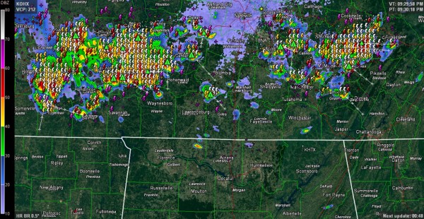
Tennessee Storms Dropping South
Storms over Tennessee have intensified tonight and are dropping south toward North Alabama.
They are lined up generally along I-40 southwest of Nashville toward Jackson TN. They extend east of the Music City to near Crossville. They are dropping south and southeast at 20 mph. They have tremendous amounts of lightning and torrential rains. The one northwest of Waynesboro had a severe thunderstorm warning on it for a time.
Trees and powerlines are reported down in Murfreesboro southeast of Nashville. Some roads around Murfreesboro are closed by flooding. Two inches of rain fell in 90 minutes there.
Will the storms hold together as they move toward Alabama? Probably. The atmosphere is already beginning to stabilize over North Alabama, but the storms may hold together into the Tennessee Valley. They will be accompanied by gusty winds and frequent lightning.
Will they make it to the I-20 Corridor? Probably not. They should go downhill through the late evening and into the early morning hours.
But we will be watching.
Category: Alabama's Weather


