Tropical Storm Fay Strengthening

See full text of 4 pm NHC advisory on Fay below from JB.
Fay is becoming better organized this afternoon…as bands of thunderstorms rotate toward the center of circulation. The storms release heat due to condensation, and this is what helps to lower the pressure and increase the winds.
Below is a radar loop of Fay from 1130 am to 3 pm. It is hard to locate the center sometimes when it relocates itself due to storms in these initial stages of a storm instead of just moving along.

Air Force Hurricane Hunters found a flight-level (about 5,000 feet I think) 62 knot (71 mph) wind at 130 pm, and winds could briefly increase to hurricane force at the surface, before the storm makes the landfall predicted by the NHC near Punta Gorda, FL tomorrow morning.
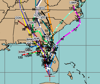
The computer models that have had so much trouble with this storm, seem to have converged on a solution bringing Fay to near or on the SW Florida coast tomorrow. But, what then? Some bring it toward the Big Bend of Florida, others keep it mainly over land, and others curve it out into the Gulf later. At this time the chances look fairly small for a direct hurricane landfall between Mobile and Panama City, and none of the intensity models takes it above Category 1 anywhere right now. However, it must be emphasized that the models change often, and while there is no reason for any big alarm in those areas, those with interests there should continue to watch this storm closely.
Category: Uncategorized
About the Author (Author Profile)
Subscribe
If you enjoyed this article, subscribe to receive more just like it.


