

Soggy Fourth of July
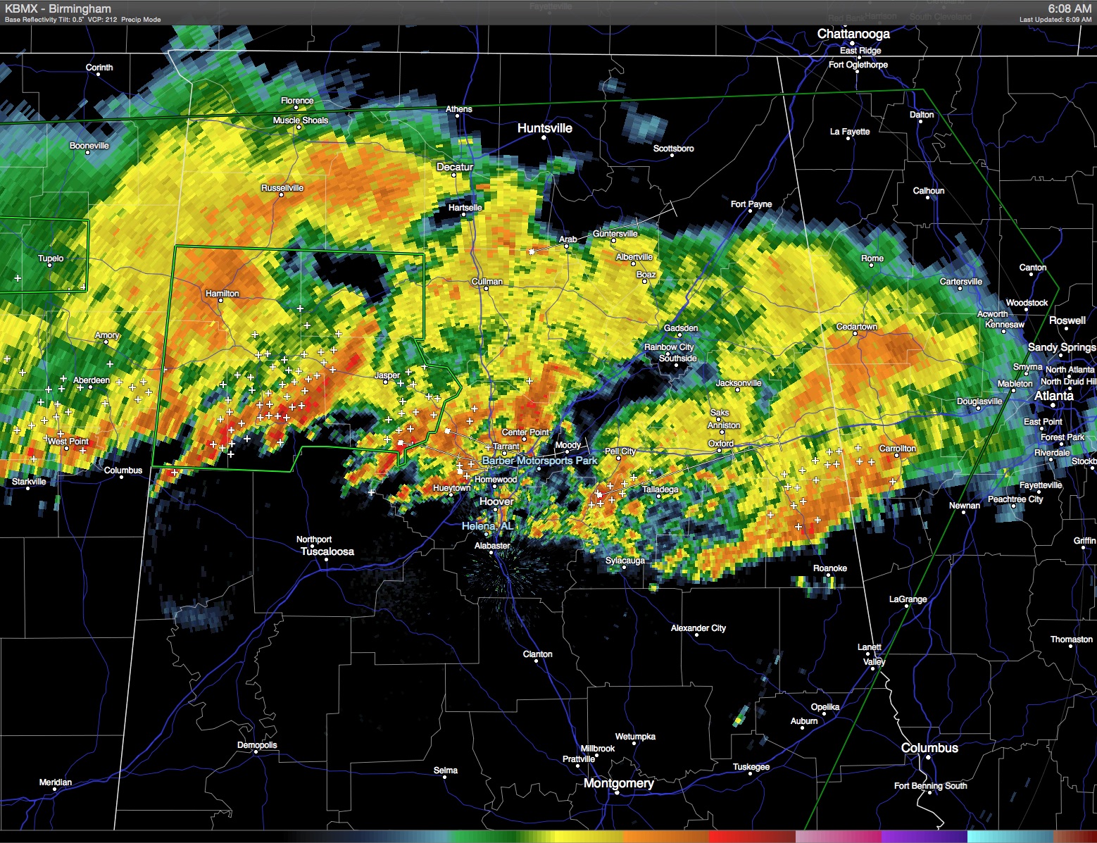
Nature is providing plenty of fireworks for the fourth of July in the form of a train of thunderstorms that stretched from Southeast Oklahoma all the way to North Georgia. Flash flood watches were posted for a sizable chunk of the Southeast US including much of the northern half of Alabama through Sunday morning. There is little change likely to occur in this weather pattern over the next 36 to 48 hours, with potential for the watch area to be extended and additional flash flood warnings added for counties generally along and north of the Interstate 20 corridor. Rain and clouds were keeping temperatures down considerably with highs only expected to reach the lower 80s. Birmingham only reached 80 yesterday for the daily high. This is a look at the latest radar image.
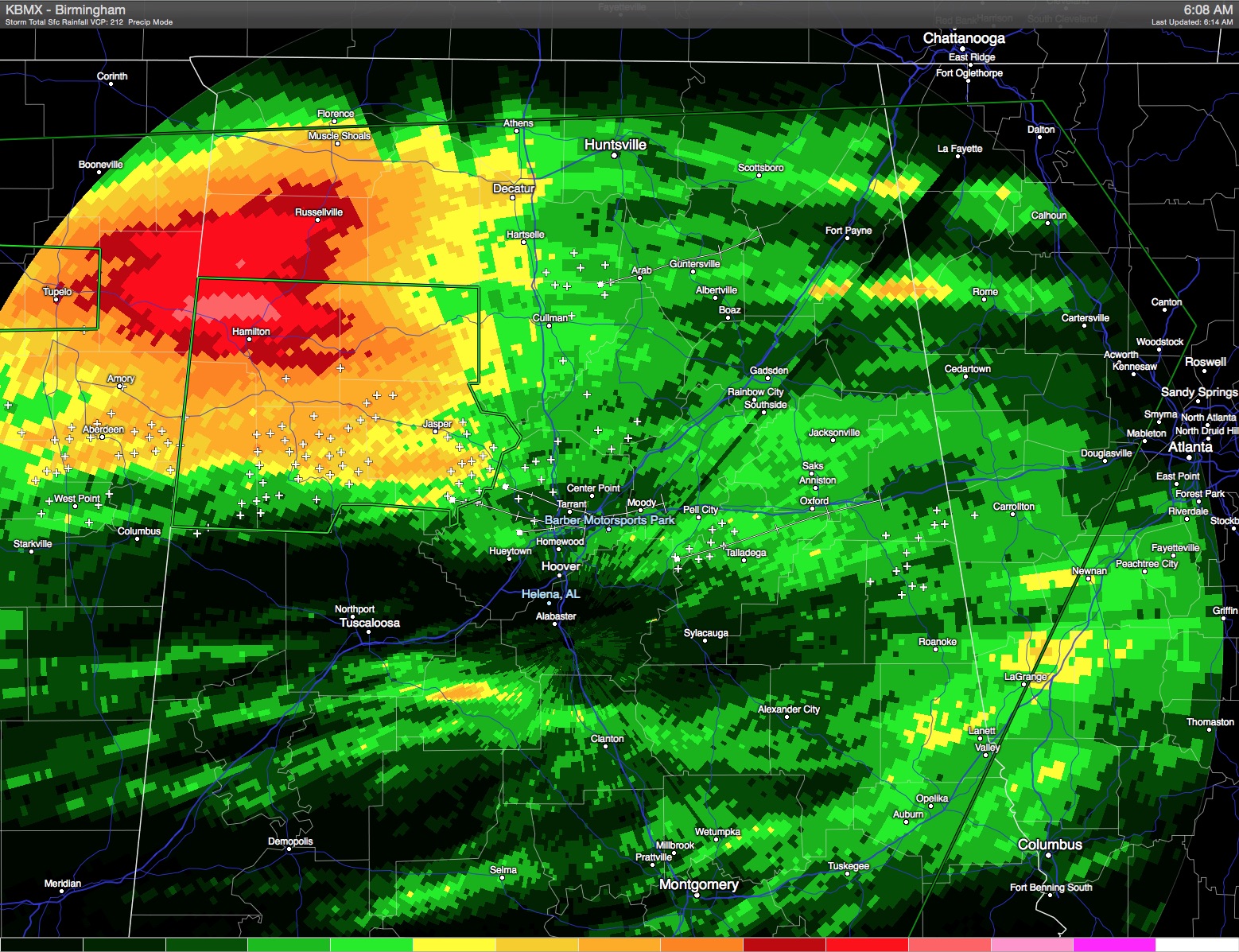
The storm total precipitation estimate also shows the impact of the training of these storms with that red area in Marion County with an estimated 8 to 10 inches of rainfall with more to come.
The upper level low will move slowly into the Central Appalachians by Monday, so I expect rainy weather to stay with us into Sunday. But by Monday as the low gets caught up by the main westerlies, we should see the atmosphere dry out at least somewhat dropping us back to more typical afternoon and early evening storms for much of the week ahead. Again, the additional clouds and presence of showers will help to hold the heat off until mid-week when we should see highs once again near seasonal values as we record values into the lower 90s.
The training of echoes today and Sunday will keep the flash flood threat high across much of Central Alabama. Additional rainfall values of 2 to 4 inches will be possible over the weekend with some higher values likely where the strongest storms occur. Remember, turn around, don’t drown. Don’t risk your life by driving into areas where water covers the roads to an unknown depth.
While the flash flood threat is very high, we also continue to see potential for isolated strong to severe storms. SPC has much of the Southeast US in the area from North Georgia westward to Oklahoma in a marginal risk area. But as the upper low moves out early next week, the risk for strong storms should drop.
The Atlantic Basic continues to be quiet thanks to the extensive area of dry air over the South Atlantic. The Eastern Pacific was a little more active with a couple of areas of disturbed weather but no named storms for now.
For folks headed to the beach, look for about 4 to 7 hours of sunshine each day through much of next week with the risk of occasional passing thunderstorms from Dauphin Island eastward to Panama City Beach. Highs will remain in the mid to upper 80s on the immediate coast, with lower 90s inland. Sea water temperatures are mostly in the low to mid 80s.
Looking out into Week 2, the long range GFS suggests another substantial ridge to our west which will bring back highs in the 90s, but the pattern evolves back to more of a trough over the eastern US by the 19th of July suggesting at least a limit to some of the summer heat.
The overall weather situation for Central Alabama remains highly fluid, so please check back here often for updates. A flash flood warning was issued for Jefferson County until 9:30 am while I was working on this post. I plan to have the next Weather Xtreme Video posted here Sunday morning.
-Brian-
Category: Alabama's Weather
About the Author (Author Profile)
Brian Peters is one of the television meteorologists at ABC3340 in Birmingham and a retired NWS Warning Coordination Meteorologist. He handles the weekend Weather Xtreme Videos and forecast discussion and is the Webmaster for the popular WeatherBrains podcast.Subscribe
If you enjoyed this article, subscribe to receive more just like it.


