Nice Mornings, Hot Afternoons
Apologies for the delay in the video this morning, and the quality, I got the blue screen of death on the laptop this morning and had to get the old one going this morning that doesn’t have all the bells and whistles of the new one.
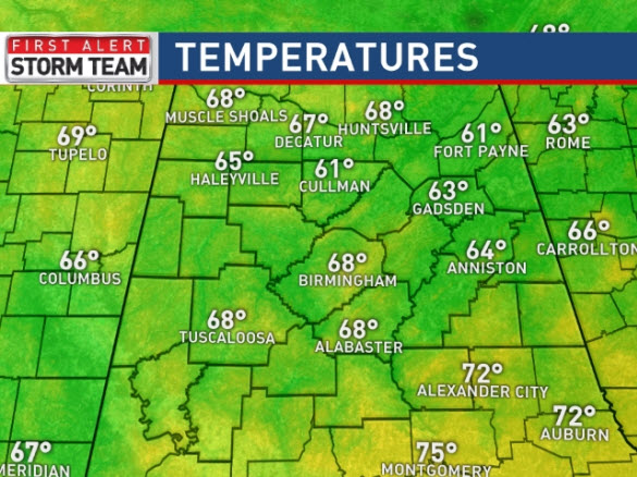
A very nice start to our Sunday across Central Alabama as most locations our into those soothing 60s continuing to give us that hint of fall. It will be another day featuring plenty of sunshine, few clouds, almost no chance of rain, low humidity, but hot temperatures. Highs this afternoon will once again climb well into the 90s with most spots across Central Alabama in the mid-90s.
ON THE MAPS: To the west of Alabama there remain an upper-level ridge. Across the eastern portions of the U.S., we are beginning to see another trough develop over Canada and it will be sliding down the eastern side of the ridge and will begin to bring us that northwesterly flow aloft that we have seen much of the summer, but mid-week, the trough is expected to be over much of the eastern half of the country and will help enhance our rain chances.
MONDAY/TUESDAY: These two day will continue to feature mainly sunny, hot, and for the most part dry conditions as the lower dew points will remain in place. Heights over the state will begin to increase and that will allow afternoon highs to increase as well. We are expecting to go from the mid-90s into the upper 90s in many spots. However, by late Tuesday, we should begin to see southerly flow return at the surface and that will allow moisture to return to Alabama by midweek.
SECOND HALF OF WEEK: From Wednesday through Friday, we are going to showers and storms become more prominent across Alabama. The upper-level trough and higher moisture levels will allow for more typical summer weather across the state. With the return of moisture that means humidity levels will be on the rise as well. For these days, expect scattered showers and storms mainly in the afternoon and evening hours. With the better rain chances will we will see highs back around the 90 degree mark.
AT THE BEACH: Highs along the coast have been ranging from 88-93 degrees, and that will continue into the week ahead. However, like clockwork each day, showers and storms will develop during the afternoon, which may run you in from the beach for a little while. Nevertheless, there will still be ample sunshine, and great weather to work on those tans. Seas are going to be running 1-2 feet, and the rip current threat is low along the Alabama Coast. However, the rip current threat is moderate along the Northwest Florida Coast, so use a bit more caution if getting in the waters in Florida the next few days. Water temps are in the mid-80s at most locations along the northern Gulf Coast. See the complete Gulf Coast 7 Day Planner here . The Gulf Coast Beach Forecast is presented by Gulf Shores Plantation by Mandoki Hospitality Vacation Rentals. Escape to Gulf Shores Plantation where memories last a lifetime.
SPC OUTLOOK: An “Enhanced Risk” of severe thunderstorms is forecast today and tonight as severe storms are expected across the Great Lakes region today. This may include one or two organized storm clusters capable of generating swaths of potentially damaging wind gusts, in addition to severe hail, and perhaps a couple of tornadoes.
TOPIC TROPICS: For the North Atlantic, Caribbean Sea, and the Gulf of Mexico, tropical cyclone formation is not expected during the next 5 days as the basin remain very quiet.
WEEKEND SNEAK PEEK: The more active weather pattern appears to stick around for both days next weekend. That means hot and humid conditions with highs in the lower 90s. Also, we will see our daily dose of afternoon showers and storms, which is nothing too unusual this time of year.
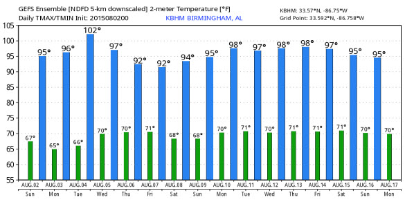
LONG RANGE MODEL ENSEMBLE: As we continue to head through the month of August, the weather looks to stay hot. Now August is known for hot weather, but average highs this time of year for Central Alabama are usually in the lower 90s. Over the next two week, model data output shows that we can expect above average temperature through at least the middle of August.
Category: Alabama's Weather
About the Author (Author Profile)
Macon, Georgia Television Chief Meteorologist, Birmingham native, and long time Contributor on AlabamaWX. Stormchaser. I did not choose Weather, it chose Me. College Football Fanatic. @Ryan_StinnetSubscribe
If you enjoyed this article, subscribe to receive more just like it.


